RANDOLAND : Saint-Martin-de-Queyrières
Formerly mainly agricultural, the commune of Saint‑Martin‑de‑Queyrières benefited from a large plain along the Durance River and a well‑exposed hillside suitable for vine cultivation at “La Vignette,” where the remains of cellars and wine presses can still be seen today.
Equip yourself with the "Randoland" leaflet, available for purchase at the Tourist Office, to solve puzzles and observe elements of the local heritage.
Description
The walk starts from the parking area near the La Miraille reuse center. Head towards the bridge. Pass in front of it without crossing, to go and observe the old mill (at the bottom of the telephone antenna) and answer the first question.
- Continue in the direction of the village. Pause to observe, on your left, the Saint‑Sébastien chapel.
- Carry on along the road and, about 120 meters further on, take the stairs going up towards the town hall.
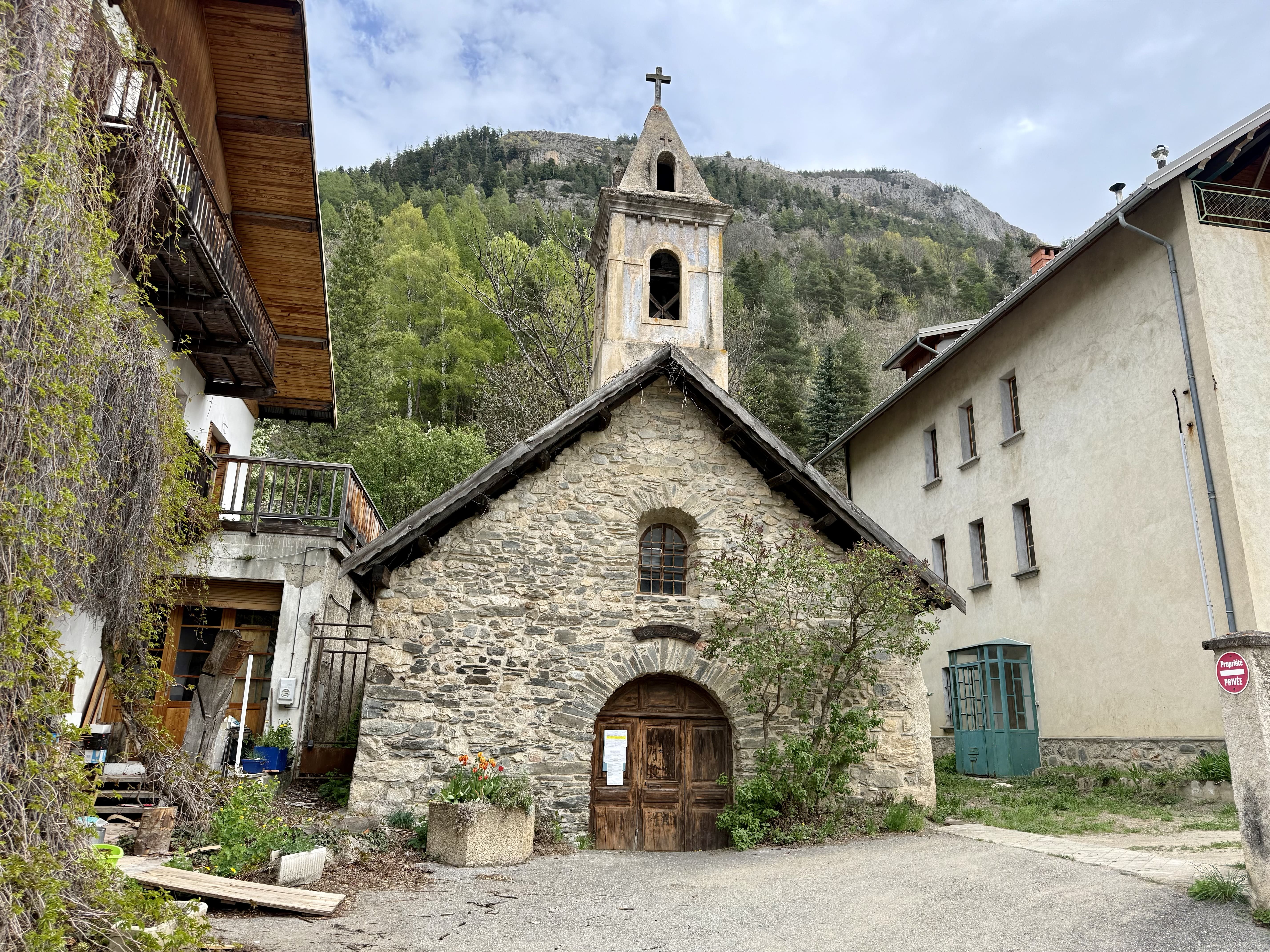
- Walk down the street towards the bell tower to go and observe the church.
- Move on to the Saint‑Roch road and pause in front of the façade with the inscription “Vins en gros.”
- Continue along this street until you reach the edge of the village. Observe the Saint‑Roch chapel, just after the café‑gallery Le Rocher Baron (l’Avers).
- Turn back and go up the stairs located just before number 109 on the street. Turn left, then carry straight on to reach the level of the church fountain. Take the street going uphill, pass in front of the town hall, and continue up to number 158 on the street to look for the inscriptions carved into the façade, on the street side.
- Carry on climbing and stop in front of the cross, or a little further on in front of the chapel and its fountain.
- Keep going uphill to leave the village. Continue to the bridge without crossing it. Just before the bridge, turn left into the path that runs downhill. Follow the Saint‑Sébastien stream back to the chapel of the same name. Turn right to return to the starting parking area.
End of the walk.
- Departure : Ressourcerie la Miraille
- Arrival : Ressourcerie la Miraille
- Towns crossed : Saint-Martin-de-Queyrières
Altimetric profile
Recommandations
Before setting out on a hike, check the weather conditions. Be especially vigilant with children, particularly in non-pedestrian areas. The route is undertaken entirely at your own risk, and Randoland and the Tourist Office accept no responsibility in the event of an accident.
Mountain rescue: 112
Please respect the work of farmers, operators, and landowners.
Close all gates behind you.
Take all your rubbish with you.
Do not cut across the route through the meadows.
Information desks
23 Avenue de la République, 05120 L'Argentière-La Bessée
Transport
Public transport >> https://services‑zou.maregionsud.fr/fr/
Think car‑pooling as well >> www.blablacar.fr
For more information, contact the nearest Tourist Information Office to the starting point of the hike.lescommunes+1
Access and parking
From Briançon, follow the N94, pass the reuse center and make a U‑turn at the roundabout. Then come back to the reuse center to park.
Parking :
details.BAMwidget
Source

Report a problem or an error
If you have found an error on this page or if you have noticed any problems during your hike, please report them to us here: