Route No. 10: Le Bois de la Draille
Medium
Corresponding snowshoeing ratings :
R2
Target group:
- Occasional hikers (1-2 hikes per week)
- Active families with sporty children (aged 10 and over)
Description
To check snow conditions, click here.
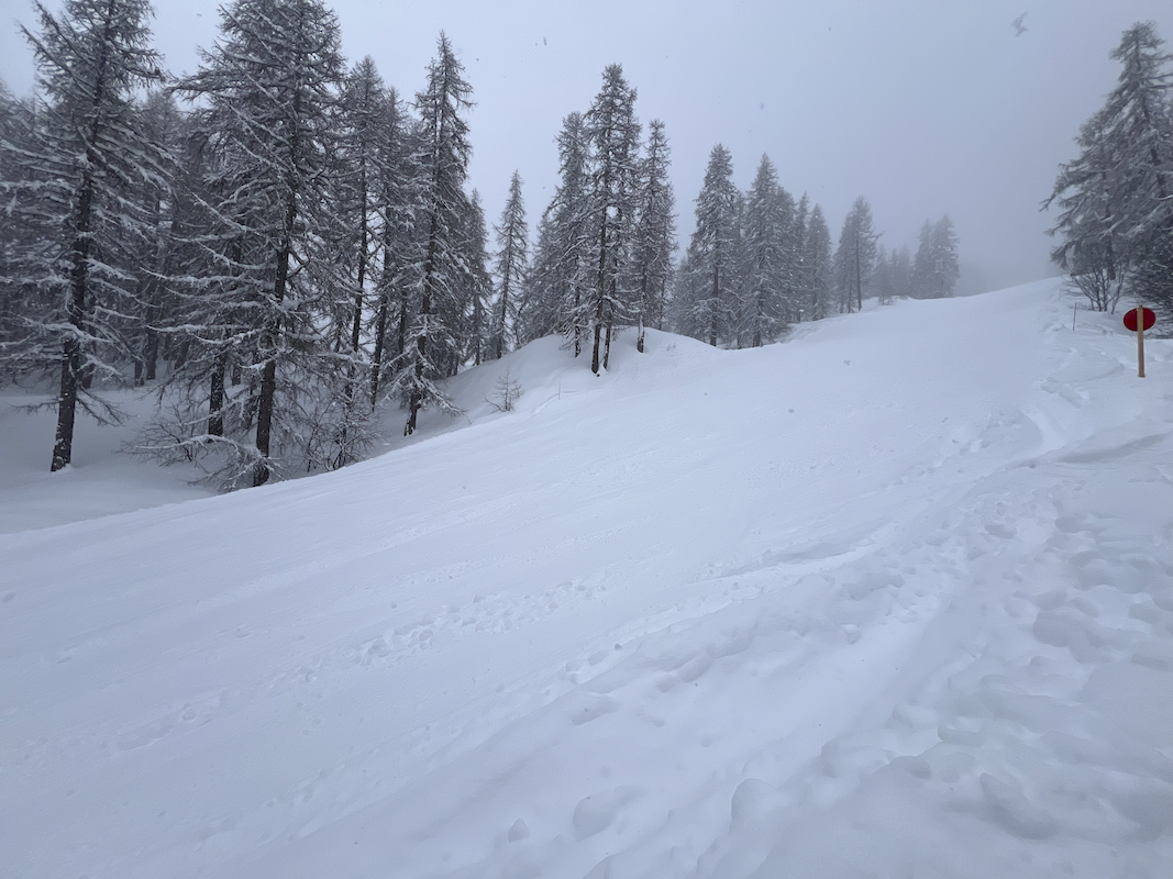
3.7 km traverse from the top of TSD Bergerie - 25m D+ and 370m D-
Set off on an adventure among the larches with this itinerary that crosses the resort between 2100 and 1700 meters altitude.
Markings: blue or purple flags and black "pedestrian/snowshoe" signs on a yellow background.
Description:
Board the Bergerie chairlift at station 1600, just above the tourist information office.
- Once at the top of the chairlift, exit to the left and enter the larch forest about 200 m to the east. A signpost indicates the start of the route. Follow the signs (stakes with blue flags and signs attached to trees) for about 1 km.
- Leave the forest and carefully cross the red slope "La Draille" to reach the undergrowth on the other side. Ascend to the right to leave the blue "Les Crêtes" trail. Follow the signs.
- Cross the blue slope "les Crêtes" to rejoin the path on the other side and skirt the Lac des Hermes to the east. A small section of the trail is shared with the Pré Rouge ski touring route.
- Pass to the right of the picnic tables and descend into the clearing north of the lake.
- Cross the clearing and exit to the east.
- Cross the stream and join the shared path leading down to the cabane du Laus.
- Turn left at the crossroads in front of the cabane du Laus.
- At the crossroads at the bottom of the path, turn right behind the restaurant l'Étoile des Neiges and follow the downhill route back to the Nordic chalet.
- Towns crossed : Puy-Saint-Vincent
Gear
Water and snacks
Warm clothing (avoid jeans)
High boots (hiking, rigid snow boots)
Walking poles
Sun screen
Sunglasses
Hat/cap
Small first-aid kit
Sensitive areas
Black grouse - winter
- Impacted practices:
- , Land
- Sensitivity periods:
- JanFebMarAprDec
- Contact:
- Parc National des Ecrins
Thierry Maillet : thierry.maillet@ecrins-parcnational.fr
Membre de l'Observatoire des Galliformes de montagne
Virginie Dos Santos : ogm.vds@gmail.com
Blandine Amblard : ogm.amblard@gmail.com
Golden eagle
- Impacted practices:
- Aerial, , Vertical
- Sensitivity periods:
- JanFebMarAprMayJunJulAug
- Contact:
- Parc National des Écrins
Julien Charron
julien.charron@ecrins-parcnational.fr
Recommandations
https://www.nordicalpesdusud.com/domaines/puy-saint-vincent
A few rules :
→ You use these itineraries at your own risk. Find out about the weather conditions and avalanche risks published by Météo France. Also, don't hesitate to ask at tourist information offices or the Nordic chalet before you set off.
→ Night-time activities on Nordic areas are prohibited. It must be supervised by a professional and must be authorized by the slopes service.
→ Respect the furnishings: signage, prohibitions, trail directions, picnic tables, footbridges, banners, milestones, road signs.
→ Several itineraries are shared with other users: cross-country skiers, touring skiers, mountain bikers, sled dogs, rando-luge, trail runners. Give them the right of way, always walk along the edge of the trail and be vigilant when using these shared trails.
→ Many routes cross downhill ski slopes; be vigilant and give priority to skiers.
→ Don't walk in the cross-country ski rails, step over them.
→ Don't hesitate to take along a topo-guide so that you have all the information on snowshoeing itineraries to hand.
→ Don't overestimate your possibilities!
→ Dogs are tolerated, on a leash, off the cross-country ski trails (dogs are forbidden on the Lauzet itinerary of the Puy-Saint-Vincent ski area, reserved for approved sled dog teams). Don't forget to pick up after your dog.
→ Take your garbage with you!
→ Don't hesitate to take public transport rather than the car to get to the Nordic area.
Please note : This information is given for guidance only. It is your responsibility to check the weather report before you leave and not to overestimate your possibilities. The Tourist Office and the PNE cannot be held responsible in the event of an accident. In case of doubt, contact professionals: instructors or equipment hire companies.
Mountain Rescue : dial 112
6 points of interest
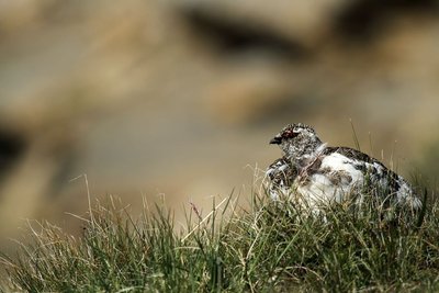
Lagopède alpin en été - mâle - Jean-Philippe Telmon - Parc national des Écrins  Fauna
FaunaThe ptarmigan and the mountain hare
The rock ptarmigan, a member of the grouse family, and the mountain hare are both perfectly adapted to high-altitude life. Among other adaptations, they turn white in winter in order to escape the attention of predators, and they are grey-brown in summer. In addition, their feet are covered with feathers or fur, and act as snowshoes when moving over snow. They are particularly threatened by the increasingly early arrival of the flocks in the alpine pastures, the boom in winter tourism and climate change.
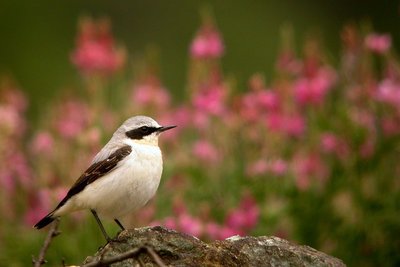
Le traquet motteux - Damien Combrisson - Parc national des Écrins FaunaThe wheatear
This bird is common in the alpine pastures and can be recognised by its grey back, its pale underside, its white rump, its white tail the shape of an inverted black "T" and by a black stripe over its eye. During the mating season, the male's underside is pinkish. Perched on a large rock, he utters a loud «uit uit» alarm call, which gives his presence away. A migratory bird, he arrives from Africa in April and flies south again in September.
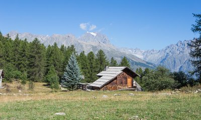
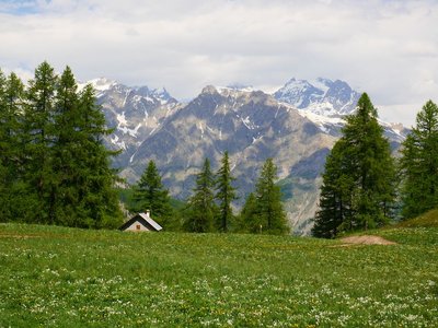
Chalet - Jan Novak  Panorama
Tournoux
The Tournoux plateau is a small paradise with its cool meadows, its occasional renovated chalets made from stone and larch wood and its view over the Tête d'Aval, an imposing limestone peak forming part of the Montbrison massif. Whether on a mountain bike, on foot or on cross-country skis in the winter, this spot is always an invitation to stop for a break!
Le Laus - Marie-Geneviève Nicolas - Parc national des Écrins  Vernacular heritage
Le Laus
A number of old alpine pasture chalets or hamlets, often renovated, are dotted across the Puy-Saint-Vincent resort. These are the Chalets du Laus. Le Laus is a place name designating a lake. In fact, just after the chalets, although not a lake, there is a flat, marshy area which is no doubt a small filled-in lake. So no point in bringing your pedalo!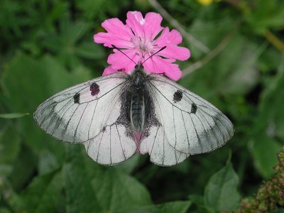
Semi-apollon - Gourreau Jean-Marie - Parc national des Écrins FaunaThe clouded Apollo
White, almost translucent in places, with just a few black spots, this butterfly is a cousin of the better-known mountain Apollo. It lives in clearings in open woods where the plant on which the female lays her eggs grows, and on which its caterpillars feed: the corydalis. It is a mountain butterfly.
Lecture de paysage - Office de tourisme du Pays des Écrins PanoramaReading the landscape
The Vallouise valley is a tributary valley on the right-hand bank of the Durance. It is made up of three municipalities: Vallouise-Pelvoux, Les Vigneaux and, looking down from the heights, Puy-Saint-Vincent. This 25 km-long valley is dominated by numerous peaks, ranging in altitude from 980 metres, at the confluence of the Durance, to the peak of the Barre des Écrins at 4,102 metres (the highest point in the Les Écrins massif) and covers 18,541 hectares. Lying at the centre of the crystalline massif, the Vallouise valley is the gateway to the Parc National des Écrins and boasts exceptional and varied landscapes and a diverse wealth of fauna and flora.