Gyronde P1: from Vallouise to the Vigneaux
Description
The first 100 meters of the descent are caracterized by a succession of sporty class IV rapids, with a few big rocks that can be detected beforehand. Progressively, the Gyronde widens which allow for an easier, calmer descent, passing from class IV to class III.
Disembarking is mandatory at the wooden bridge of the Vigneaux, as a classe VI passage is situated downstream in the village.
Return : From the bridge, a parking lot is accessible on the left bank and allows to access the road that leads back up to Vallouise.
- Towns crossed : Les Vigneaux and Vallouise-Pelvoux
Gear
Helmet and life jacket are mandatory
Inflatable kayaks are not suitable and strongly advised against
Sensitive areas
Short-toed snake eagle
- Impacted practices:
- Aerial,
- Sensitivity periods:
- MarAprMayJunJulAugSep
- Contact:
- Parc National des Écrins
Julien Charron
julien.charron@ecrins-parcnational.fr
Short-toed snake eagle
- Impacted practices:
- Aerial,
- Sensitivity periods:
- MarAprMayJunJulAugSep
- Contact:
- Parc National des Écrins
Julien Charron
julien.charron@ecrins-parcnational.fr
Recommandations
- Disembarking at the Vigneaux is mandatory due to a class VI passage downstream.
- Careful with floods after a storm
- Careful with logjams, especially at the beginning of the season
- Please take your trash with you
Attention : Experience is required in order to navigate these rivers without professional supervision. This information is provided for general guidance. Checking weather reports, water levels, flow rates and conditions before embarking is under your responsability. The tourism office and the national park will not be held responsable in case of an accident.
If you have doubts, please ask a professional. Kayak schools, instructors and renting shops of the valley are here to help you.
Mountain Rescue : dial 112
Weather report
Water levels at l’Argentière : https://www.rdbrmc.com/hydroreel2/station.php?codestation=1125
20 points of interest
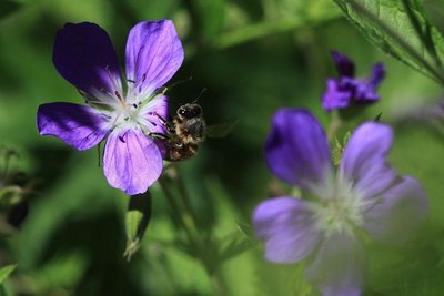
Géranium des bois - Marc Corail - Parc national des Écrins  Flora
FloraWood cranesbill
The path is edged with large clumps of a plant with purple flowers, the wood cranesbill. The leaves are palmate and divided into 5 to 7 incised and indented lobes, This common plant grows in meadows and cool woods. The «geraniums» we see on balconies are in fact pelargoniums, distant cousins originally from South Africa and cultivated for ornamental purposes.
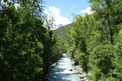
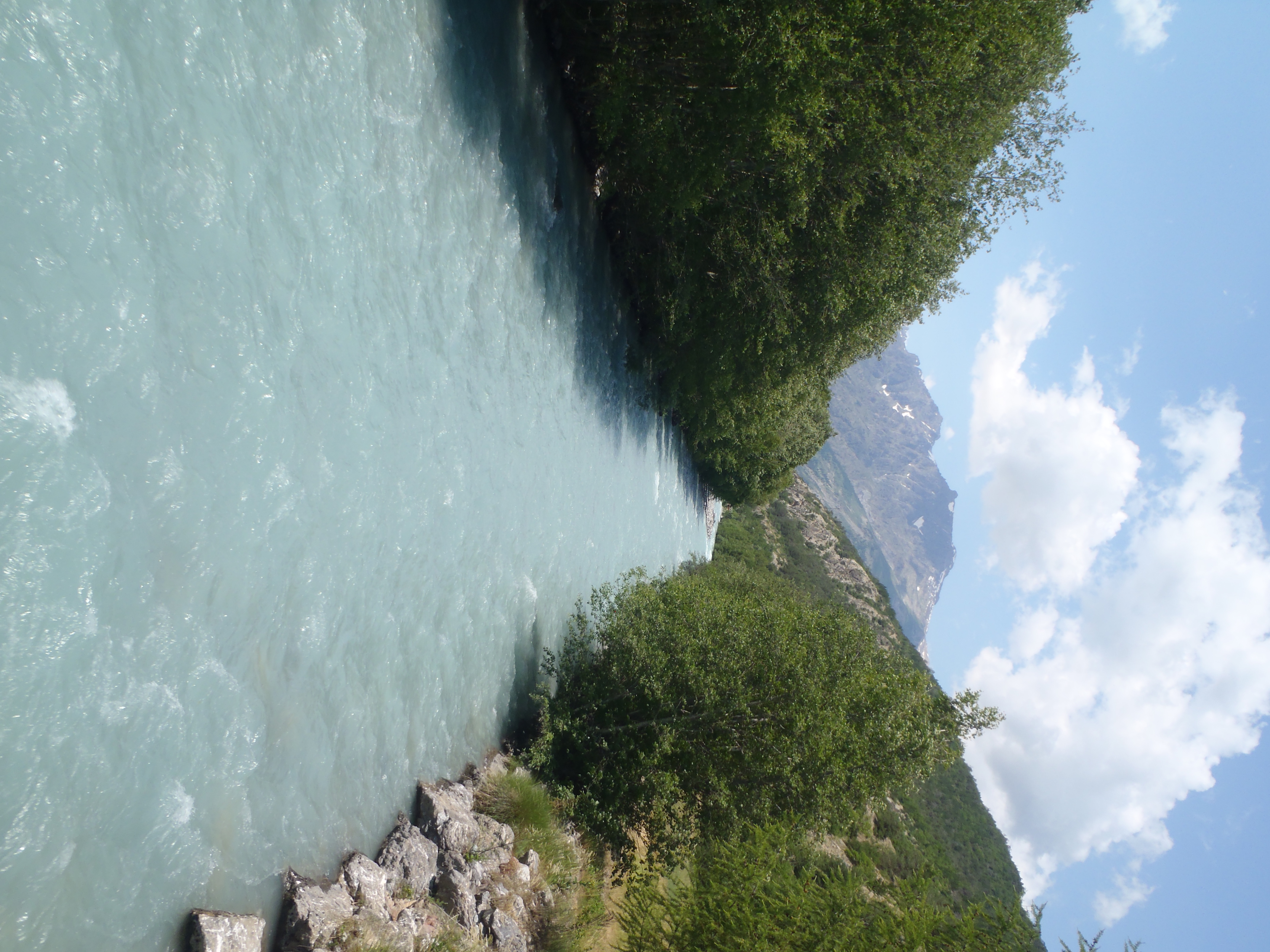
La Gyronde - Office de tourisme Pays des Écrins  Water
WaterThne Gyronde
No, we're not in south-west France where the Gironde flows! The Gyronde (spelt with a «y»!) is the river that flows between Vallouise and L'Argentière-La Bessée, where it flows into the Durance. It originates from the Gyr and Onde mountain streams which merge in Vallouise.
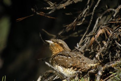
Le torcol - Damien Combrisson - Parc national des Écrins  Fauna
FaunaThe northern wryneck
In the spring, an odd song can be heard among the old trees in the orchard, a loud song similar to that of the green woodpecker, only slower. It is that of the northern wryneck. This bird owes its name to the extreme way it extends and twists its neck when it feels threatened. Its French name torcol fourmilier is a reference to the fact that it feeds on ants (fourmils in French). Difficult to spot because its plumage merges into the colour of the tree trunks, it gives its presence away by its song when it returns from its migration.
Aiguilles de pin sylvestre - Parc national des Écrins FloraOn the south-facing slope, pine forest
The track passes through a forest of Scots pines, mixed with some downy oak trees. It is a forest typical of those found in the lower south-facing slopes (those exposed to the sun) in the intra-alpine valleys.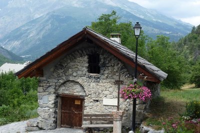
Le four banal du Grand Parcher - Office de tourisme Pays des Écrins  Vernacular heritage
The hamlet of Parcher
The hamlet of Grand Parcher stands on the alluvial cone formed by the Grand Parcher mountain stream, and on either side of it. It is made up of several old houses and the seventeenth-century chapel of Saint-André. It has two sun dials painted onto its walls. One of them bears the saying HORA INCERTA CUNTIS, ULTIMA MULTIS (This hour is uncertain for all, it is the last hour for many). Food for thought!
Le chévrefeuille d'Étrurie - Bernard Nicollet - Parc national des Écrins FloraEtruscan honeysuckle
Etruria was the territory of the Etruscans, in the area of present-day Tuscany. Although this honeysuckle does not grow only in Tuscany, it is Mediterranean, however, and only grows naturally in the wild in the southern half of France. Being a plant that needs warmth, it does not grow at altitude, except here where the south-facing slopes are particularly dry and warm. Its large pink and yellow flowers are highly perfumed.
La Maison du Parc de Vallouise - Thierry Maillet - Parc national des Écrins  History
The Vallouise Park Centre
Vallouise Pelvoux is a municipality within the Parc National des Écrins. Renovated in 2014, the Park Centre ("Maison du Parc") houses the offices of the local Park staff and has a spacious visitor reception area. It offers a permanent interactive exhibition inviting discovery of the territory and its heritage features, a temporary exhibition space on the upper floor and an audiovisual room (screenings and talks). It is currently in the process of applying for the "Tourisme et Handicap" tourism and disability label. Admission is free and so, too, are most of the activities in offer.
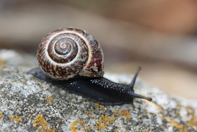
Hélice des Alpes - Damien Combrisson - Parc national des Écrins FaunaThe Alpine copse snail
On the damp banks of the stream, hidden in the grass, is a snail with a beautiful golden brown shell speckled with brown, decorated with a dark spiral stripe. It has a black body. The alpine copse snail is relatively rare and, as its name suggests, it is found in the Alps. It is a sub-species of the ordinary copse snail, which is present across Europe.
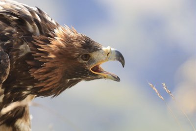
Aigle royal - Cyril Coursier - Parc national des Écrins FaunaThe sun bird
So what is the identity of this sun bird? It's the royal, or golden, eagle of course. Although it is telling the time here, in the surrounding natural landscape it hunts marmots. But what becomes of it in winter when the marmots hibernate deep in their burrows? It's a lean time. It has to make do with a hare or ptarmigan, and in particular the carcasses of chamois which have not survived the winter or have been killed in an avalanche.
Un frêne - Marie-Geneviève Nicolas - Parc national des Écrins FloraThe ash tree
Even in winter, the ash can be recognised from its large black leaf buds. The leaves are compound. A pioneer species that grows easily, the ash has long been used by man for everyday needs: its foliage was used to feed cattle and its hard, flexible wood was used to make a variety of objects such as tool handles. Its French name frêne often appears in local place names too: Freissinières (frêne noir - black ash), Le Freney etc. Evidence of its historical importance to human communities..
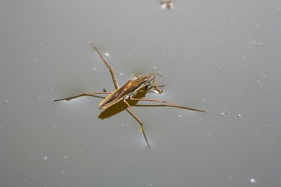
Un gerris - Bernard Nicollet - Parc national des Écrins FaunaThe gerris
Some strange creatures are moving jerkily over the surface of the water: Gerrises, insects related to bedbugs. Like a true insect, they have six legs and they «skate» across the water using their intermediate and hind legs which are covered in hairs to make them water-resistant. They are carnivorous and anything on the water surface, dead or alive, is good to eat! They catch their prey with the forelegs, sucking up the juices with their strong proboscis!
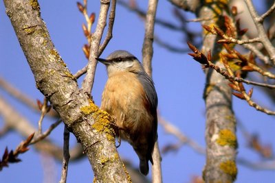
La sittelle torchepot - Damien Combrisson - Parc national des Écrins FaunaThe wood nuthatch
With its strident calls, this little acrobat gets itself noticed. With a blue-grey back and a black stripe over its eyes, it works its way down the tree trunks upside down in search of insects. It nests in old woodpecker nests but if the diameter of the entrance is too large it reduces it with mud, to protect its young from predators. Hence its French name torchepot (a reference to edging the rim of a vessel).
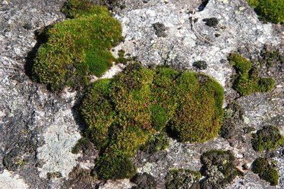
Mousses sur roche - Dominique Vincent - Parc national des Écrins FloraMosses
There are mosses growing on the old wall. Mosses are plants which appeared long before flowering plants, 440 million years ago. They live in damp environments but can withstand long periods of drought. They have very few requirements and can colonise virgin areas. They then contribute to the slow formation of humus, thus allowing more demanding plants to establish in their turn. There are 800 species of moss in France, all of them beautiful!
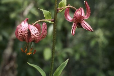
Le lis martagon - Marie-Geneviève Nicolas - Parc national des Écrins FloraThe martagon lily
Many martagon lilies grow at the side of the path. This superb plant has large hanging flowers with curved-back petals, which are pink speckled with purple and exposed orangey stamens. Its leaves are elongated and whorled. It grows in meadows and cool woods. Although common here, it is rare in many French regions. In fact, picking it is prohibited or regulated.
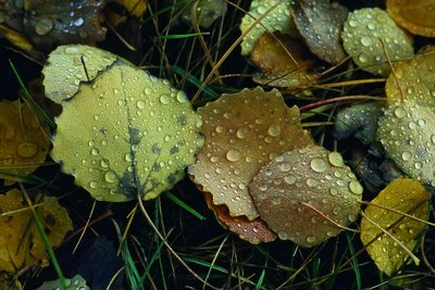
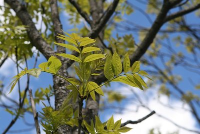
Des feuilles de tremble - Bernard Nicollet - Parc national des Écrins FloraRiparian forest
The track runs through a wood of alder, beech, aspen and oak, the remnant of the natural forest growing at the water's edge, called riparian forest. This type of forest is in decline everywhere, destroyed by urbanisation and by containment of the mountain streams. Yet it is an essential zone for the fixation of river banks and for purifying the water. Since it offers specific natural habitats, it also plays a major role in maintaining biodiversity.
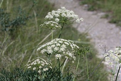
Le laser siler - Cédric Dentan - Parc national des Écrins FloraThe laserwort
After the bridge, a large plant with flowers arranged in umbels (in other words, an umbellifer) clings to a small rock bar to the right of the track, the laserwort. This plant belongs to the family Apiaceae, which used to be called umbellifers, and grows in dry areas. It has a distinctive feature: in autumn, the basal part of the stem breaks of its own accord and the entire plant, now dry, sets off rolling down the hillside like a large ball, or is blown by the wind.
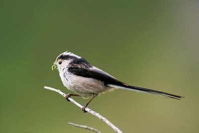
La mésange à longue queue - Robert Chevalier - Parc national des Écrins FaunaThe long-tailed tit
Some birds are causing a stir in a tree, constantly coming and going and uttering little calls. They are round and black and pinkish beige in colour with a long tails, hence their name, the long-tailed tit. They are resident birds and always live in small groups. They inhabit forests, undergrowth and even gardens. They weave a ball-shaped nest out of lichen, moss and dry grass.
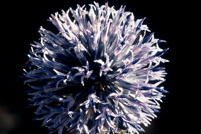
L'échinops à tête ronde - Bernard Nicollet - Parc national des Écrins FloraThe great globe thistle
On the edge of the path grows a tall plant with quite wide and smooth leaves, and completely round whitish or very pale blue flower clusters. This is the great globe thistle, a relatively rare plant. It is a cousin of the southern globe thistle which can be seen everywhere in dry places. This one is smaller and has clusters of bluish flowers and spiny leaves.
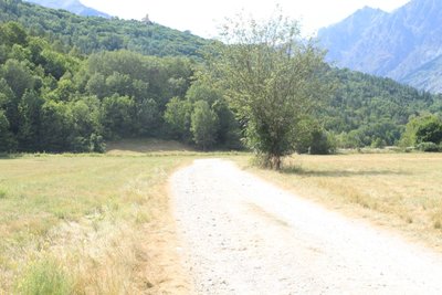
L'ubac - Office de tourisme du Pays des Écrins  Geology and geography
The "ubac"
The track rises gently up the right-hand bank of the Gyronde, on the "ubac" side. The "ubac" is the slope that is exposed to the north, so it is in shadow in winter when the sun is low in the sky.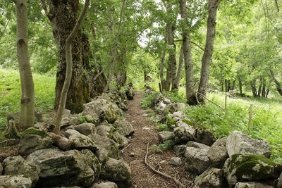
Les Eyssarts - Dominique Vincent - Parc national des Écrins HistoryLes Eyssarts
The track runs through a place called Les Eyssarts, which gave this circuit its name. This name comes from the word essart which refers to «a place that has been cleared, most often to create agricultural land». A few meadows, but above all former canals and low walls hidden under the advancing forest, bear witness to this past use of the land.