THEMED PATH: The precipice path
“Climbing above the Durance, this itinerary gives a measure of the importance of this valley which became a key communication route in the distant past. You start to imagine all those people who have passed through it on foot over centuries and centuries;” Marie-Geneviève Nicolas,park ranger at the Parc National des Écrins
Description
From the chapel, cross the bridge over the Biaysse and immediately fork right and then left after 100 metres.
- Take the gently rising path which twists and turns past some fine low stone walls and comes out onto a cultivated flat area.
- Follow the path to the belvedere, making a there-and-back detour.
- Follow the road right for 500 metres until you reach Pallon. Go through the village and, as you are leaving it, 100 metres after the wash house, take the track on the right which runs past a house with green shutters. The path drops back down to the chapel in Rame.
- Departure : Chapel in Rame, Champcella
- Arrival : Chapel in Rame, Champcella
- Towns crossed : Champcella and Freissinières
Altimetric profile
Recommandations
Follow the safety instructions to the letter and be sure to use safety installations, in particular near the precipice edge.
Binoculars are recommended for observing the fauna
Check weather conditions before setting off.
Rescue services contact details: Secours Montagne (Mountain Rescue): +33 (0)4 92 22 22 22 or 112
Show consideration for the work of farmers, livestock keepers and owners
Close all gates behind you
Take your litter home
Do not take shortcuts across pastureland
Information desks
23 Avenue de la République, 05120 L'Argentière-La Bessée

Vallouise Park house
, 05290 Vallouise
Information, documentation, models, exhibitions, screenings, product sales and works of the Park. Guided tours for school, reservation required. The new Park House opened in Vallouise since June 1, and offers visitors an interactive permanent exhibition inviting to explore the area and its heritage. A temporary exhibition space will allow a renewed offer. Finally, the device is completed by an audiovisual room to organize screenings and conferences Free admission. All animations of the Park are free unless otherwise stated.
Transport
Public transport >> www.pacamobilite.fr
Consider car-sharing >> www.blablacar.fr
For more information, ask at the Tourist Information Office nearest to the trail starting point.
Access and parking
10 km from L'Argentière-La Bessée, take the N94 and the D38.
Parking :
9 points of interest
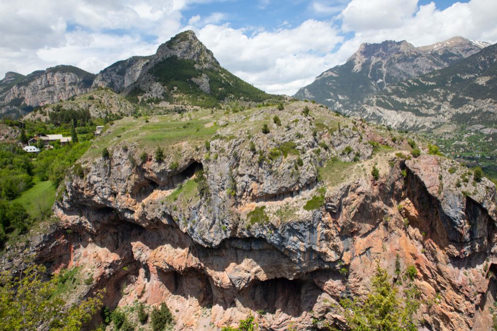
Plaine de Rame et la Chapelle pris de la cime des Rampes - Jean-Philippe Telmon - Parc national des Écrins  History
The lost village
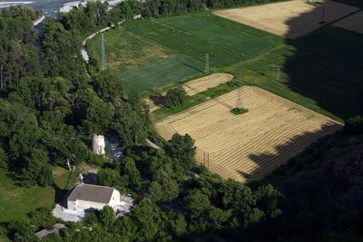
In ancient times, the Durance valley was a key communication corridor. Rama was a kind of staging post on the Roman road. In the Middle Ages, Rama was a small town with a noble's château. But the village was devastated by the capriciousness of the Durance and the Biaysse rivers on numerous occasions and the inhabitants gradually deserted the site, moving to neighbouring villages. The attachment of the parish of Rame to that of La Roche in 1446 is indicative of this decline.
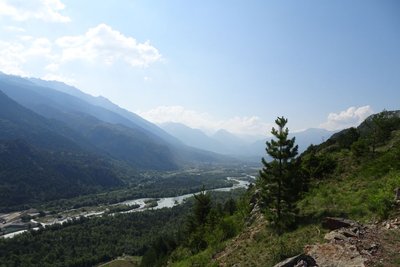
La vallée de la Durance - Office de tourisme Pays des Écrins  Geology and geography
The high Durance valley
Protected from Atlantic influences by the Massif du Pelvoux, the high Durance valley has a very dry climate with wide seasonal temperature fluctuations. It has grasslands very similar to the steppes of Central Europe which are rare in France. It is part of the Natura 2000 “Steppique durancien et queyrassien” (Durance and Queras valley steppes) site.

Le sentier du Gouffre - Thibault Blais Photographie HistoryThe Sentier du Gouffre - the ravine path
The Sentier du Gouffre has sometimes been described as a Roman road, but we do not know the exact route the Roman road followed. One thing is certain, it used to be used by the villagers to reach their fields and vineyards, and for any other journeys they had to make.
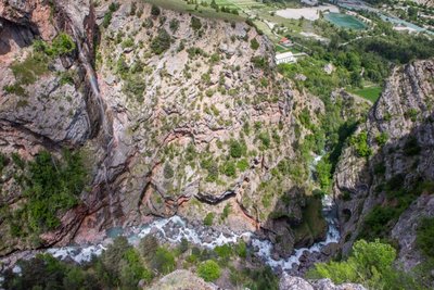
Gourfouran, Champcella et la vallée de la Durance - Thibault Blais Photographie Geology and geographyThe Gourfouran ravine
During the major glaciation periods, the enormous Durance glacier carved out its bed to a depth of more than 200 metres. The glacier in the Freissinières valley flowed onto the surface of this glacier. When they melted, they left a large "stair step”, called a confluence terrace. Flowing into the Durance, the Biaysse gradually carved a path through this terrace, first as a subglacial mountain stream and then after the glacier melted.
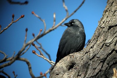
Choucas des tours - Damien Combrisson - Parc national des Écrins  Fauna
FaunaThe jackdaws
At small colony of jackdaws has taken up residence in the ravine. A member of the Corvidae family, the jackdaw can be identified by its small size and grey plumage with darker wings and a black cap on its head. It is a species not often found in the mountains, remaining in the valley bottoms and generally found no higher than 1,500 metres. It nests on cliffs or in human habitats: castles, towers and ruined buildings!

Grand-Duc d'Europe - Pascal Saulay - Parc national des Écrins FaunaThe Eurasian eagle-owl
Europe's biggest owl, the Eurasian eagle-owl lives in the vicinity of the ravine. It nests on ledges on the cliff faces but has a very large home range, hutting not only large insects but also snakes, voles, hares etc. Unfortunately, it is very sensitive to disturbance and has already deserted a large number of rock faces now used as climbing routes and equipped with via ferratas. It has also fallen victim to collisions with electricity lines.
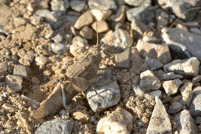
Oedipode turquoise - Mireille Coulon - Parc national des Écrins FaunaCricket of every colour!
A red flash on the path, then nothing... But yes, there it is! A completely grey cricket has settled on a grey rock. Another red flash: he has flown off and settled again... creating surprise and confusion. Just what is needed to confuse a predator. This is how the red-winged grasshopper protects itself, folding its colourful wings down under its wing covers when at rest, and thus exploiting its camouflage colouring. A blue flash? That's its cousin, the blue-winged grasshopper!
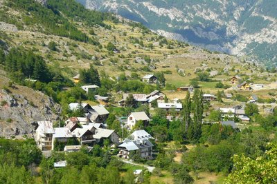
Hameau de Pallon - Office de tourisme Pays des Écrins Geology and geographyA Medieval tsunami?
Pallon marks the entrance to the ancient glacial valley of Freissinières, enclosed behind a bar of hard rock. As they melted, the glaciers left behind a lake, trapped by this bar. It is said that this natural dam has been breached on numerous occasions. In the Middle Ages, suddenly released into the Gourfouran gorge, the water is said to have laid ruin to the village of Rame, standing on the plain.
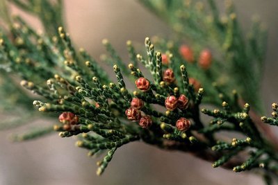
Genévrier thurifère (fleurs femelles) - Bernard Nicollet - Parc national des Écrins  Flora
FloraJuniperus thurifera or Spanish juniper
This small tree is present in North Africa, the Iberian Peninsula and in a few departments in southern France, including the Hautes-Alpes. It is regarded as a relic from a warmer period far back in history. It has found a refuge in well exposed situations, on warm sunny slopes. Its needles are in the form of scales, lying against the branches. It is a monitored species.
More information
details.BAMwidget
Source

Report a problem or an error
If you have found an error on this page or if you have noticed any problems during your hike, please report them to us here: