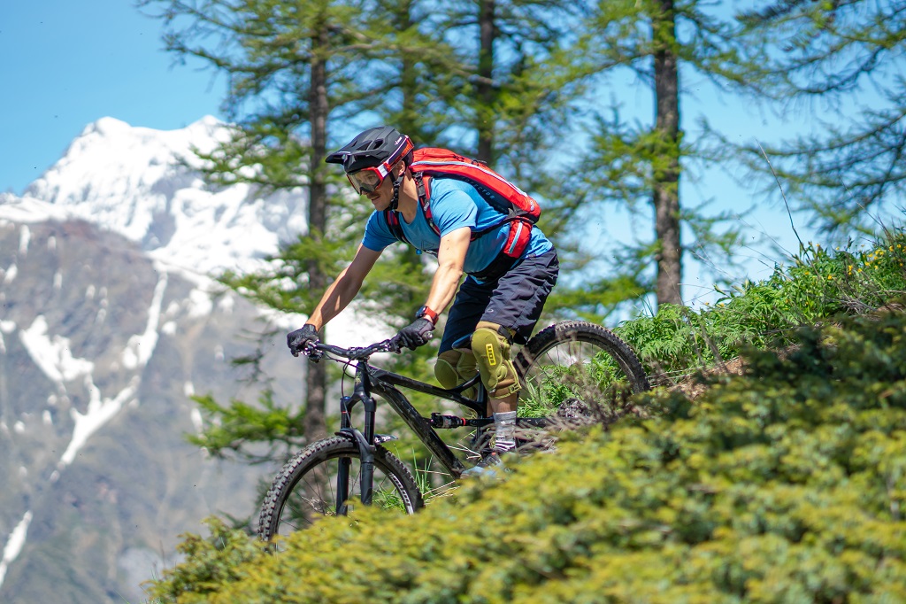
Le Bois du Truc circuit (no. 12)
Description
The circuit starts not far from the La Roche-de-Rame mayor's office ("Mairie") near the Bouchouse mountain stream. First, follow its left-hand bank, going upstream. 430 metres further up, cross the mountain stream and carry on along the right-hand bank. At the crossroads, turn right to cross the mountain stream again and carry on uphill towards Bel Pinet.
- Turn left towards Le Lauzet, winding uphill along a stony track
- When you reach Bel Pinet, at 1,400 m altitude, take the track on the left to the Calvary and the Bois du Truc
- 150 metres past the Calvary, at 1,561 m altitude, turn left to the Bois du Truc up a final short ascent
- 180 metres further on, at a set of gate posts, turn left onto the path below the track, to tackle the single-track descent (Caution! Quite steep downhill section to reach the path, and technical stretches on the path)
- At the Bois du Truc, at 1,510 m altitude, carry on down the single-track section towards Le Bathéou and La Roche-de-Rame (exercise caution on the numerous technical stretches)
- At Le Mas des Ducs, at 1,290 m altitude, carry on straight ahead towards Bathéou and La Roche-de-Rame
- Continue straight ahead along the track above Le Bathéou, heading towards Les Gillis and the dwellings
- At Les Gillis, turn left onto the D338. Then, 60 metres further on, turn left again to the village centre
- Turn right and follow the Bouchouse downstream on the right-hand bank. Then, after 170 metres cross the mountain stream, which brings you back to the mayor's office and your starting point
- Departure : La Roche-de-Rame mayor's office ("Mairie")
- Arrival : La Roche-de-Rame mayor's office ("Mairie")
- Towns crossed : La Roche-de-Rame
Altimetric profile
details.BAMwidget
Recommandations
Rescue services contact details: Secours Montagne(Mountain Rescue): +33 (0)4 92 22 22 22 or 112
Take your litter home
Do not take shortcuts across pasturelandInformation desks
23 Avenue de la République, 05120 L'Argentière-La Bessée

Vallouise Park house
, 05290 Vallouise
Information, documentation, models, exhibitions, screenings, product sales and works of the Park. Guided tours for school, reservation required. The new Park House opened in Vallouise since June 1, and offers visitors an interactive permanent exhibition inviting to explore the area and its heritage. A temporary exhibition space will allow a renewed offer. Finally, the device is completed by an audiovisual room to organize screenings and conferences Free admission. All animations of the Park are free unless otherwise stated.
Transport
Public transport >> www.pacamobilite.fr
Consider car-sharing >> www.blablacar.fr
Access and parking
Parking :
Sensitive areas
Short-toed snake eagle
- Impacted practices:
- Aerial,
- Sensitivity periods:
- MarAprMayJunJulAugSep
- Contact:
- Parc National des Écrins Julien Charron julien.charron@ecrins-parcnational.fr
11 points of interest
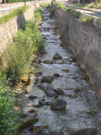
Torrent de Bouchouse - Office de tourisme du Pays des Écrins  Water
WaterBouchouse mountain stream
The Bouchouse mountain stream is fed by the Le Pansier and La Pisse mountain streams 1,900 metres above sea level. It crosses the municipality of La Roche-de-Rame, supplying it with water. This mountain stream then flows into the Durance below the municipality.
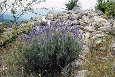
Lavande à feuilles étroites - Bernard Nicollet - Parc national des Écrins  Flora
FloraThe narrow-leaved lavender
The narrow-leaved lavender has greenish-grey leaves and violet flowers. It grows in sunny areas, a reminder that the Pays de Écrins is in the Southern Alps after all! Not to be confused with the lavandin, this plant naturally grows on rocky slopes in the mountains of the Midi. The word «lavender» is thought to come from the Latin "to wash". This etymology suggests that lavender was used at a very early date to perfume washing.
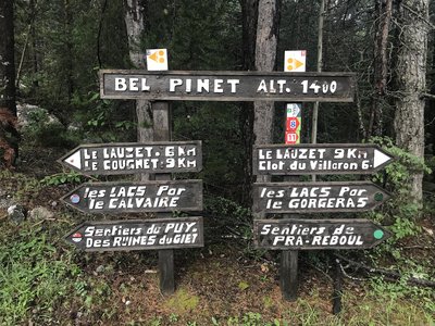
Bel Pinet - Office de tourisme du Pays des Écrins  History
Bel Pinet
Bel Pinet stands at 1,400 metres above sea level in the Bouchouse valley, in the municipality of La Roche-de-Rame. Bel Pinet, or Bel-Pinet, designates the slopes under the rocky cliffs of the Oumbras. It was once irrigated by the Bel Pinet Canal, which suggests that it used to be cultivated and would therefore have been less wooded. The term "Pinet" simply means a place planted with pines (Pinus in Latin). So Bel Pinet means a beautiful place planted with pines, or a beautiful pine wood.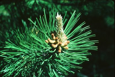
Pin sylvestre - Parc national des Écrins FloraPine forest
The path runs through a forest of Scots pine, recognisable by its orangey trunk, especially at the top. This tree is very drought-resistant (it is very limey soil here) and can also withstand low temperatures. It is therefore found in large numbers in the intra-alpine valleys.
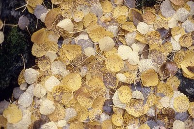
Daniel Roche - Parc national des Écrins FloraThe aspen wood
Here, a wood of aspen trees, with smooth greenish trunks and round, crenulated leaves, adopt magnificent autumn colours. The petiole («tail») of aspen leaves is flat and twisted and can therefore be caught by the slightest breath of air. This has the effect of making the foliage tremble, hence its French name bois de tremble!
Marbre rose - Office de tourisme du Pays des Écrins HistoryThe Pink Marble of Combe Mounière
In the nineteenth century, there were four quarries in La Roche-de-Rame. They exploited deposits of metamorphosed limestone which was pink in colour. One of these, the Combe Mounière quarry, produced stone which was used in particular in the construction of the new Cathedral of Saint-Arnoux in Gap, between 1866 and 1904. When exposed to the elements, the surface of the limestone takes on a grey patina.
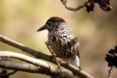
Cassenoix moucheté - Damien Combrisson - Parc national des Écrins  Fauna
FaunaThe spotted nutcracker
A harsh call sounds from the forest. A jay perhaps? No, a nutcracker, its cousin. With dark, white-spotted plumage, this bird's strong beak can break open hazelnuts (although not walnuts as suggested by its name in French, cassenoix (walnut breaker)) and in particular it can dissect Swiss pine cones in order to reach the pine nuts inside. It inhabits high forests. It buries Swiss pine nuts in the ground to store up food for the winter. When winter comes, it will find the pine nuts again even under a thick layer of snow. Those it forgets will germinate.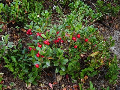
Raisin d'ours - Nicollet Bernard - Parc national des Écrins FloraThe bearberry
The bearberry is a small bush which grows no taller than 20 centimetres. Its small, glossy, evergreen leaves are reminiscent of those of the lingonberry (Vaccinium vitis idaea) but they are not as thick and, above all, its fruits are much less appetising, although they are edible. It will depend on your tastes!
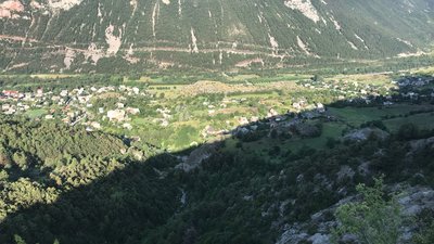
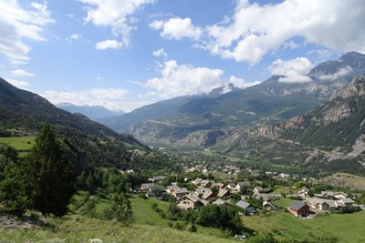
La Roche-de-Rame - Office de tourisme du Pays des Écrins  Panorama
La Roche-de-Rame
A magnificent view over the municipality of La Roche-de-Rame which lies entirely on the left-hand bank of the Durance. Like L'Argentière-la-Bessée, its recent history has been profoundly marked by industry which saw rapid expansion in the early twentieth century. Well known for its natural stretch of water, a glacial lake, the hamlets of the municipality are dotted across the slopes. Higher up, two large valleys are carved into the massif, forming a fork with the Bouchouse and Queyras valleys.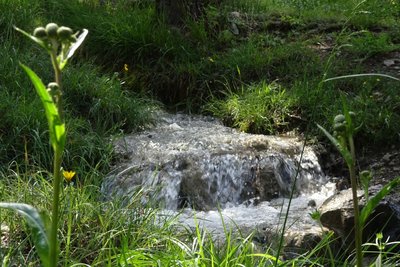
Le Canal de Serre-Duc - Office de tourisme Pays des Écrins WaterThe Serre-Duc canal
The district of Serre-Duc lies between Le Bathéoud and the rocky slopes. The Serre-Duc irrigation canal allowed the circulation of water. It is now abandoned but its course can still be made out among the pine trees and lavender. Its water intake was situated upstream of the Coumbal de Satan and the canal was used to irrigate the entire district.
Vue sur la vallée de la Durance - Office de tourisme Pays des Écrins PanoramaView over the Durance valley
Protected from Atlantic influences by the Massif du Pelvoux, the high Durance valley has a very dry climate with wide seasonal temperature fluctuations. It has grasslands very similar to the steppes of Central Europe which are rare in France. It is part of the Natura 2000 “Steppique durancien et queyrassien” (Durance and Queras valley steppes) site.
More information
Source

Report a problem or an error
If you have found an error on this page or if you have noticed any problems during your hike, please report them to us here: