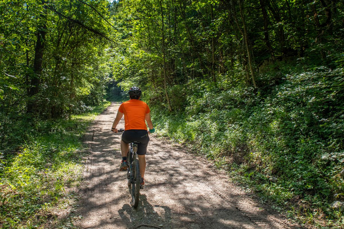
The Grande Traversée des Hautes-Alpes (GTHA) in the Pays des Écrins
The GTHA is the highest medium-altitude mountain bike route in France. It starts in La Grave-Villar d'Arène and ends in Laragne-Montéglin, thus taking you through 50 kilometres of the territory of the Pays des Écrins. Along the way you will get to know the territory and its communities through its remarkable landscapes and heritage. So, all you need to do is jump on your bike and set off on the adventure.
For more information on the GTHA itinerary, visit the Département des Hautes-Alpes website .
Altimetric profile
Recommandations
Rescue services contact details: Secours Montagne (Mountain Rescue): +33 (0)4 92 22 22 22 or 112
Show consideration for the work of farmers, livestock keepers and owners
Close all gates behind you
Take your litter home
Do not take shortcuts across pasturelandInformation desks
23 Avenue de la République, 05120 L'Argentière-La Bessée
110 route des Alberts - Station 1400, 05290 Puy Saint Vincent 1400 m
Place de l'Eglise, 05340 Vallouise

Vallouise Park house
, 05290 Vallouise
Information, documentation, models, exhibitions, screenings, product sales and works of the Park. Guided tours for school, reservation required. The new Park House opened in Vallouise since June 1, and offers visitors an interactive permanent exhibition inviting to explore the area and its heritage. A temporary exhibition space will allow a renewed offer. Finally, the device is completed by an audiovisual room to organize screenings and conferences Free admission. All animations of the Park are free unless otherwise stated.
Transport
Public transport >> www.pacamobilite.fr
Consider car-sharing >> www.blablacar.fr
Sensitive areas
- Impacted practices:
- Land, Vertical
- Sensitivity periods:
- JanFebMarAprMayJunJulAugSepOctNovDec
- Contact:
LPO PACA antenne de Briançon
0492219417
hautes-alpes@lpo.fr
Peregrine falcon
- Impacted practices:
- Aerial, Vertical
- Sensitivity periods:
- FebMarAprMayJun
- Contact:
- Parc National des Écrins
Julien Charron
julien.charron@ecrins-parcnational.fr
Short-toed snake eagle
- Impacted practices:
- Aerial,
- Sensitivity periods:
- MarAprMayJunJulAugSep
- Contact:
- Parc National des Écrins
Julien Charron
julien.charron@ecrins-parcnational.fr
Short-toed snake eagle
- Impacted practices:
- Aerial,
- Sensitivity periods:
- MarAprMayJunJulAugSep
- Contact:
- Parc National des Écrins
Julien Charron
julien.charron@ecrins-parcnational.fr
12 points of interest
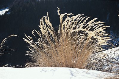
La calamagrostide argentée - Denis Fiat - Parc national des Écrins  Flora
FloraAchnatherum calamagrostis or silver spike grass
This member of the Gramineae family (now called Poaceae) forms large clumps on stony, dry and sunny ground. It grows in abundance here on the track embankment, taking advantage of the sunlight allowed through by the break in the forest. Its inflorescences reflecting silvery-gold glints are made up of flowerets with long edges. They create a very misty effect in the late summer when the plant is mature, forming large shimmering bouquets in the evening sunlight. .
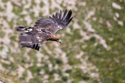
Aigle royal - Pascal Saulay - Parc national des Écrins  Fauna
FaunaThe eagles of the Tête d'Aval
Eagles can be seen gliding around the Tête d'Aval. In the hottest part of the day, they circle on the thermals rising above the limestone cliffs. Having gained height in this way, they can reach their hunting territory without having to flap their wings.
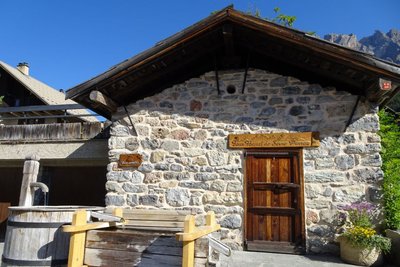
Le four banal des Vigneaux - Office de tourisme Pays des Écrins  Vernacular heritage
The communal oven
Legend has it that the Lord caused a communal oven to be built and kept it maintained. The local people could use this oven in exchange for the payment of a levy. Families would prepare and knead their own dough at home and then bring it to the oven for baking. Names were drawn by lot to establish their turns.
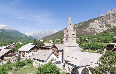
Eglise des Vigneaux - Blandine Reynaud - PDE  History
The village of Les Vigneaux
In spite of the altitude, the region's dry climate and the local growing conditions of limestone and sediments facing due south made the planting of grapevines possible as far back as the tenth century. The municipality owes its name to the presence of these vineyard operations, which were very significant in the late nineteenth century. The almost simultaneous appearance of the phylloxera aphid and the Briançon train, bringing wine from Provence, spelled the end of this activity here.
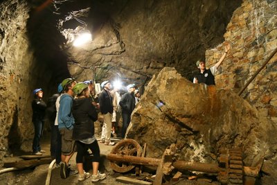
Les mines d'argent - Thibault Blais Photographie Vernacular heritageThe silver mines
The path passes close to the silver mines which gave L'Argentière its name (argent meaning "silver"). They were first worked in the early Medieval period and later abandoned before exploitation resumed again in the nineteenth century. They were finally closed in 1908. Since 1992, the site has been the subject of archaeological excavations, with major work to clear materials carried by the Fournel when in flood. They can be visited with a guide (by appointment), leaving the visitor in awe: how much ingenuity has been involved in extracting the silver-bearing galena!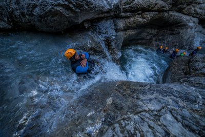
Canyoning - Fournel - Jan Novak Photography  Water
WaterThe Fournel
The Fournel mountain stream gives generously. Its water makes up a large proportion of the town's drinking water, supplies the irrigation canals, is used for hydropower and offers a recreational area valuable to the local economy in the form of its canyon, located in the gorge connecting it to the Durance. Being a mountain stream, it is impetuous, but sills have been built lower down and it has been dammed to prevent natural disasters. Numerous mountain streams have received the same treatment…
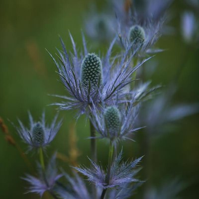
Chardon bleu - Jan Novak FloraThe blue globe thistle
The Fournel valley is well known for having the biggest colony of blue globe thistles in the Alps. This colony is growing in Les Deslioures, at the end of the road. But there are other colonies in the valley, like this one. Because this rare species is adapted to high-mountain hay meadows, agro-environmental measures have been introduced to delay grazing or hay cutting until the late summer so that it has time to set seed.
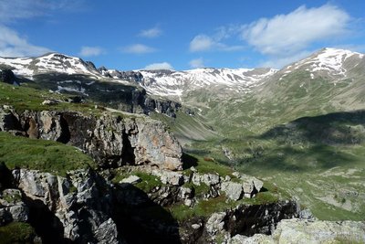
Vue sur le col des Lauzes - Blandine Delenatte - Parc national des Écrins  Pastoralism
The Crouzet-les-Lauzes alpine pasture
This trail passes close to the Cabane des Lauzes, the "base camp" used by the shepherd or shepherdess responsible for the Crouzet-les-Lauzes alpine pasture. The lower areas of this pastureland are difficult to oversee as they are covered by forest where it is easy to lose sight of animals among the larches. The higher areas, exploited in August, are very remote.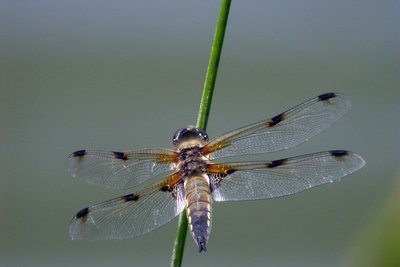
La libellule à quatre taches - Damien Combrisson - Parc national des Écrins FaunaThe four-spotted chaser
Dragonflies can be seen gliding around the lake One of them is relatively easy to identify: the four-spotted chaser. It is called this because there is a spot on each of its four wings. The female lays her eggs on floating vegetation and the larvae are aquatic. The dragonfly feeds primarily on mosquitoes and midges which it catches in mid-air. The male and female also mate while in flight... A real acrobat!
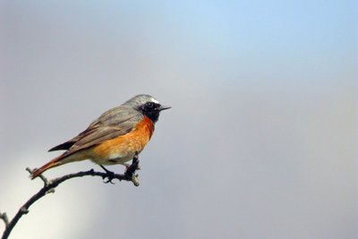
Le rougequeue à front blanc - Damien Combrisson - Parc national des Écrins FaunaThe common redstart
The common redstart can be told apart from its cousin, the black redstart by its white eyebrow (hence its French name which is translated as "white-browed redstart") and its orange breast. At least for the male, since the female of both birds is duller and brownish, but the female common redstart also has an orangey tail. It returns from Africa in early April and searches the areas to find a hollow in a tree or in an old wall where it builds its nest.
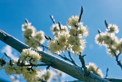
Prunier de Briançon - Bernard Nicollet - Parc national des Écrins FloraHuile de marmotte - marmot oil
In times past, the inhabitants of Freissinières used oil for cooking and lighting. Walnut or almond oil was difficult to produce at this high altitude. The Briançon plum tree or marmottier, however, can withstand the mountain conditions, and the yellow fruits of this tree contain kernels. These kernels were pressed in mills to produce an oil with medicinal virtues: marmot oil. .
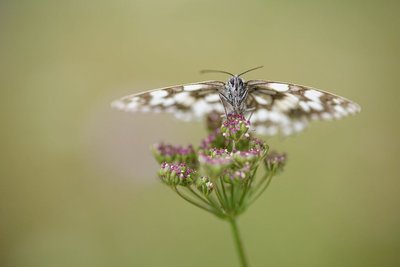
Le demi deuil - Mireille Coulon - Parc national des Écrins FaunaThe marbled white
Numerous butterflies can be seen enjoying the sunshine along the way. One is very easy to recognise. Completely black and white, maybe the person who gave it its French name demideuil («half in mourning) was a pessimist! In England, however, its name "marbled white" puts the emphasis on its white colour. It is a common butterfly and its caterpillars feed on grasses.
More information
details.BAMwidget
Source

Report a problem or an error
If you have found an error on this page or if you have noticed any problems during your hike, please report them to us here: