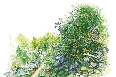
Le Col des Terres Blanches from Dormillouse
”Once we finally got to the plateau overlooking Lac du Fangeas and the Faravel pastures, at the foot of the Rochelaire, a huge bird soared up out of the blue. No doubt about it - with its diamond-shaped tail, it is a bearded vulture passing through the region!"
Blandine Delenatte and Jean-Philippe Telmon, regional park keepers
Description
Park at Les Cascades car park, at the end of the road and at the end of the Freissinières valley. Take the path on the left, where the entrance to the National Park is, and three information panels (you will pass a footbridge on the right that leads to the winter trail). Cross the bridge over the Oules torrent and continue along the looping path alongside a large waterfall, then cross an area of scree. This “summer” trail is in an avalanche zone and is not visited in winter. The trail is wide and the climb is gentle, and the inhabitants of Dormillouse use it to fetch food using tracked barrows.
- At the next crossroads, turn left into the path towards "Lac du Fangeas, Col des Terres Blanches" and continue the only trail along the Oules torrent as far as Lake Fangeas.
- Walk around the lake and turn left to take the footbridge upstream from the lake. From there, the Col des Terres Blanches path is marked by cairns and white markings. In places, before the ewes have passed through it, the route may be hard to see in the tall grasses: follow the cairns and zigzag your way through a series of rocky bars to reach the first plateau. Continue following the cairns across the plateau and the torrent, then follow the well-marked path up to the col.
- The way back is along the same route or via Prapic, then Col de Freissinières over 2 days.
- Departure : Les Cascades car park, Freissinières
- Towns crossed : Freissinières
Altimetric profile
details.BAMwidget
Recommandations
Camping is forbidden in the Cascades car park, bivouacking authorised over an hour’s walk from the park limits. Fire is also forbidden inside the park limits.

 In mountain pastures, protection dogs are there to protect the herds from predators (wolves, etc.).
When I hike I adapt my behavior by going around the herd and pausing for the dog to identify me.
Find out more about the actions to adopt with the article "Protection dogs: a context and actions to adopt".
Tell us about your meeting by answering this survey.
Transport
Nearest SNCF train station: l'Argentière les Ecrins - www.voyages-sncf.com then taxi (Taxi Pellegrin 06 98 88 17 78 / Taxi Billau 06 08 03 45 90)
Access and parking
From the RN 94, north of La Roche-de-Rame, head for Freissinières along the D38, then the D38B as far as Freissinières. Go through Freissinières, then follow the D238 towards the right as far as the Cascades car park, at the end of the valley. This is the end of the road and the end of the Freissinières valley, except for periods of snow, when the road is closed.
Parking :
32 points of interest

 Water
WaterThe Oules stream
It has a series of waterfalls and natural basins that make it one of the most difficult streams to descend for those who like canyoning. The footpath that leads to the Fangeas lake follows it for most of the route and the sound of rushing water in the spring and the beginning of the summer, accompany the hiker.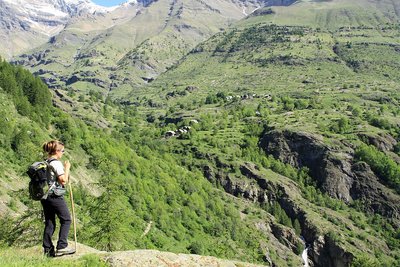
Coup d'œil sur Dormillouse en montant au Fangeas - Jean-Philippe Telmon - PNE  Panorama
View of the village of Dormillouse
The village of Dormillouse is unique in that it is levelled into several hamlets, each of which has a public amenity. Enflous, at the bottom of the village, has the mill, Escleyers has the temple, the school and the fountain, and Romans, at the top of the village, has the oven. The stone and wood houses are typical of mountain architecture in an isolated area.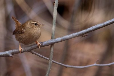
Un Troglodyte mignon saisi au repos - Pascal Saulay - PNE  Fauna
FaunaEurasian wren
This small 10 cm ball of feathers, with a white band across its eyes, is the “pétabouillou” ou la “pétouse” that lets out its powerful song from the branch it is on, tail oriented vertically. It fidgets continually in the clutter of vegetation, elusive.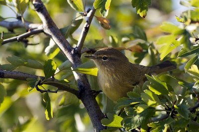
Le Pouillot véloce ... Tchiff-tchaff, tchiff-tchaff ... - Pascal Saulay - PNE FaunaCommon Chiffchaff
Although common, this small passerine is rarely seen but its «Tchiff-tchaff, tchiff-tchaff, chiff-tchaff...» song is often heard. Its song is reminiscent of the noise made by gold coins as they drop into a box one by one. The English call it the chiffchaff, the Germans Zilpzalp. In other words, this song certainly attracts attention! A migratory bird, it arrives in Les Écrins in late March or early April and nests in shrubby forests. It feeds on insects all summer before returning to overwinter around the Mediterranean rim.
La mégaphorbiaie - Pierre-Emmanuel Dequest - PNE  Flora
FloraEutrophic Tall herb fringe
This is a plant formation of tall grass that grows on damp ground. Along the Fangeas footpath on the edge of the Oules, this tall grass brushes calves and thighs.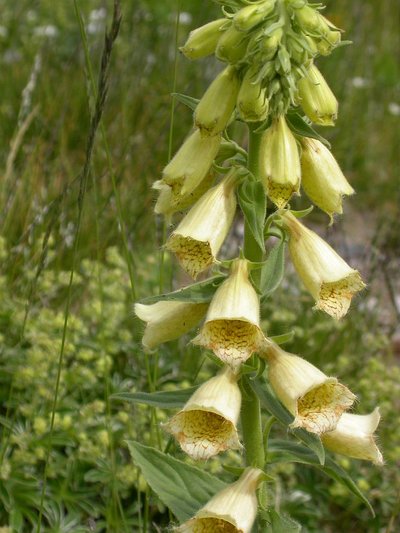
Digitale à grandes fleurs - Olivier Warluzelle - PNE FloraLarge flowered foxglove
It would be difficult to miss this large flower with its bunched yellow corolla. It gets its name from the resemblance of its flower with thimbles in which you put your finger ("digitale" referring to finger in French). In colloquial language, it is called "witch's glove" as it is a very toxic plant.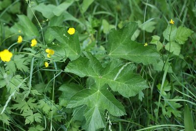
Berce commune - Cédric Dentant - PNE FloraHogweed
This large member of the umbelliferae family can grow up to 160 cm and likes rich damp soil. It gives off a smell of mandarin when it is handled. In the spring, the flower buds are hidden in a sheath of leaves and when they blossom, the umbels attract many insects.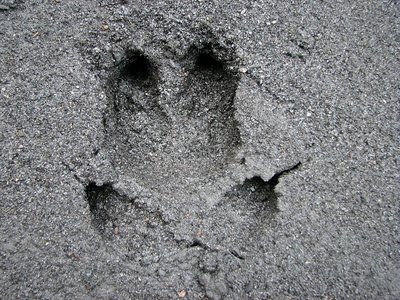
Sur les pas du sanglier - Christophe Albert - PNE FaunaBoar
There is little chance that you will come across this animal but it is likely you will see evidence of unearthing (overturned top layer of earth) or rooting (when it digs deeper into the soil). Boar root the soil with their snout in search of worms, beetle larvae, roots and tubers.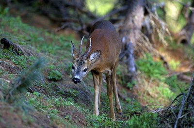
Un brocard ou chevreuil mâle à pas feutré - Robert Chevalier - PNE FaunaRoe deer
Hidden in the larch forest, the roe deer will occasionally show its fine head at dusk or dawn. It is not always easy to spot this reserved animal but traces betray its presence by the print of its frail heart-shaped hooves, shrubs stripped of their bark by yearlings rubbing the last shreds of velvet from their antlers, or scratching at the ground to mark their territory during the mating season. Sometimes a throaty barking sound may be heard.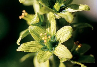
Fleur de vératre blanc - Bernard Nicollet - PNE FloraWhite hellebore
Without its flowers, it would be easy to mistake it for a yellow gentian. However, the white hellebore has alternating leaves on its stem whereas those of the gentian are opposite (forming a cup). The gentian makes a well-known aperitif, whereas the hellebore is poisonous.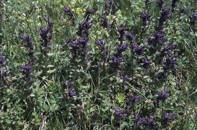
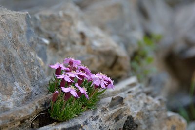
Bartsie des Alpes - Marie-Geneviève Nicolas - PNE FloraAlpine bartsia
It can be seen from afar in the green grass due to its purplish bracts that almost hide its small flowers. It is an artic-alpine species living high in the Alps and in northern Europe.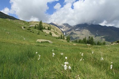
Zones humides aux environs du lac du Fangeas - Jean-Philippe Telmon - PNE WaterWetlands
The Fangeas lake is surrounded by wetlands. Its name comes from "fange", which is a marshy area.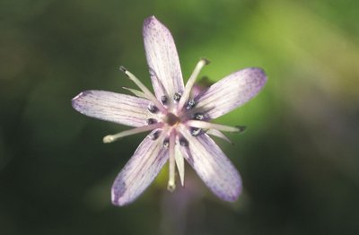
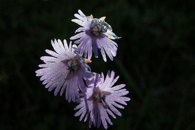
Swertie vivace - Bernard Nicollet - PNE FloraFelwort
At the beginning of August, the Felwort's violet stars open up in the sun. At the base of each of the five petals, two shiny dimples filled with nectar attract insects. It is part of the gentian family and is a beautiful, hardy flower that resists the winter season thanks to its winter bud.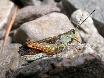
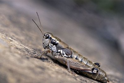
Criquet jacasseur - Blandine Delenatte - PNE FaunaLarge mountain grasshopper
From the middle of the summer, this grasshopper rubs its dark, staggered, ribbed elytra with its back legs and fills the air with the resulting repetitive sh-trrrrrrr sh-trrrrrrrr sh-trrrrrrrr...sound. When we disturb it as we walk, it flies off noisily as if it was not happy.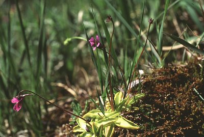
La grasette commune une carnivore qui aime les insectes - Jean-Pierre Nicollet - PNE FloraButterwort
Its light green, almost yellow leaves enable us to identify it on the soggy earth. The sticky surface of its leaves are a real trap for the gnats that venture onto them. The plant is carnivorous in order to compensate for the lack of nitrogen in the wetlands.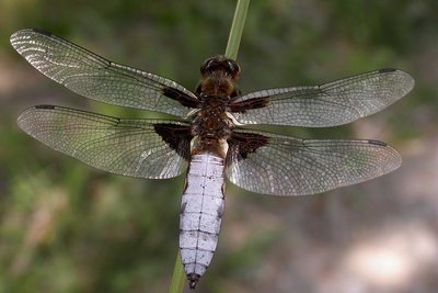
Libellule déprimée - Damien Combrisson - PNE FaunaBroad-bodied chaser
It get its French name, 'Libellule déprimée' not because it is "depressed" in a psychological way, but due to its flat abdomen. The male with its blue abdomen can often be seen flying above wet areas.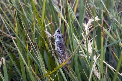
Gomphocère des alpages - Bernard Nicollet - PNE FaunaSiberian grasshopper
In the grass around the Fangeas lake, in August, several grasshoppers blend into the grass. Among them, the Siberian grasshopper has a peculiarity; it has butch arms, like Popeye. In fact, it is just that its front legs that are shaped like bulbs. Without this detail and its long steady song "creh-creh-creh-creh", it might easily go unnoticed with its green-brown colour.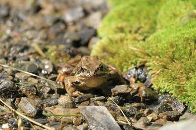
Grenouilles rousse - Jean-Philippe Telmon - PNE FaunaCommon frog
Sometimes a frog will jump in the wetlands that surround the Fangeas lake and more specifically in the rivulets that meander through the grass. Young or adult, it is the common frog, the most common in the mountains. It can live up to an altitude of 2800 m, a record! It hibernates in the ground or in the silt at the bottom of the water. In the spring, its eggs float on the surface of the water in compact clusters.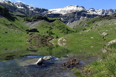
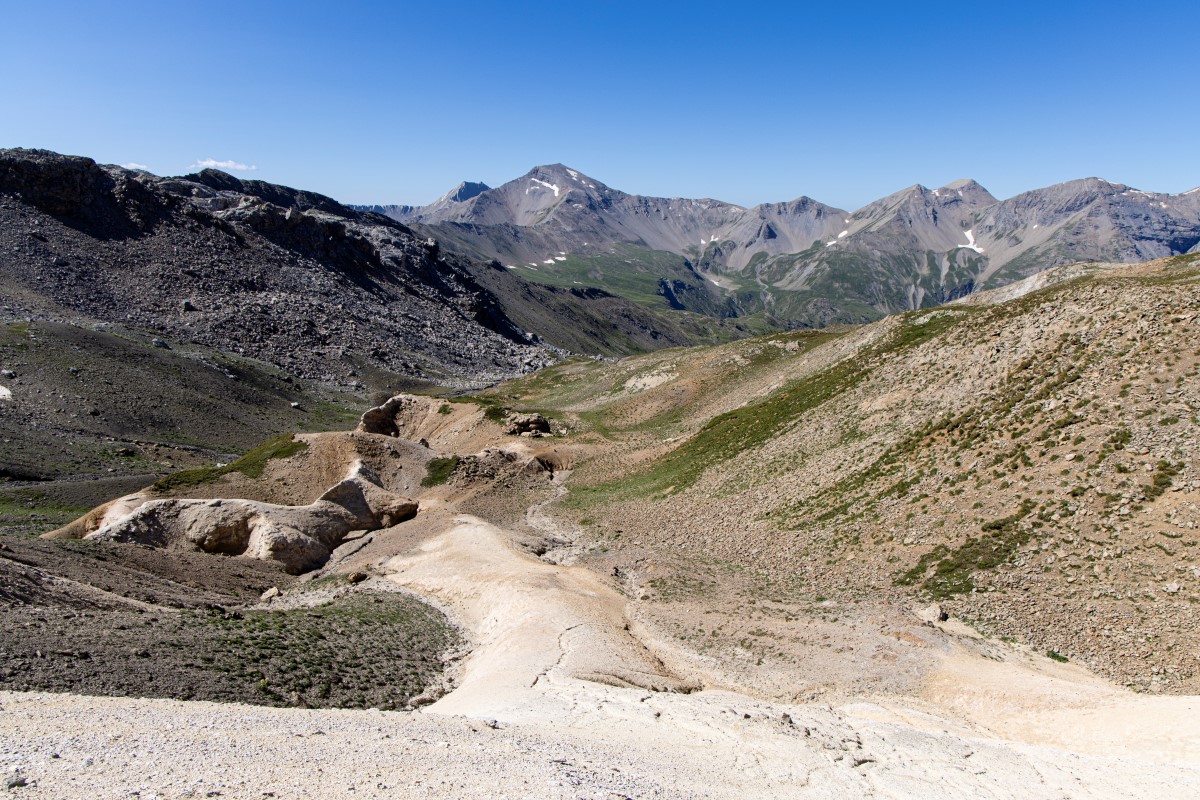
Le Lac du Fangeas et les sommets environnants - Jean-Philippe Telmon - PNE  Lake
LakeLac du Fangeas
The Lac du Fangeas is not a high-mountain lake in the strict sense of the term, although that in no way detracts from its charm. Formed in the 1960s by a landslide which blocked the mountain stream, it is shallow and the flow still passes through it.
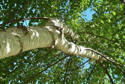
Bouleau verruqueux - Blandine Delenatte - PNE FloraThe silver birch
On either side of the walkway crossing the mountain stream above the Lac du Fangeas, the predominant tree is recognisable by its white bark, its warty branches and its weeping growth habit. In all the region's mountain valleys, bundles of young birch twigs cut before the snows were used to make brooms. Believed by some to have magic powers, they prevented evil spirits from entering the home...
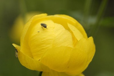
Mouche du trolle - Mireille Coulon - PNE FloraThe globe-flower
With their gold spheres on long stems swaying in the wind, globe-flowers brighten up the rich meadows surrounding the path. Proud yet modest, these flowers fold their petals over, hiding the inside from our gaze They are reserved for a little seed-eating fly which takes advantage of the mysterious yellow chamber to reproduce and drink the nectar undisturbed. The fly spreads the pollen from flower to flower and the flower provides a safe haven for the insect's larvae. Everyone wins: a two-way relationship.
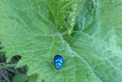
Chrysomèles des adénostyles, très reconnaissable à sa couleur caractéristique - Blandine Delenatte - PNE FaunaThe adenostyle leaf beetle
This beetle with brilliant reflections is a mountain-dweller and a lace-making specialist! Its favourite material for this work: the large leaves of the adenostyles which brush against your calves as you pass the cairns marking the route. The more the leaf is nibbled, the more it gives off a scent which attracts the beetles, which can gather on it in large numbers. But be aware, a leaf beetle on an adenostyle is not necessarily the adenostyle leaf beetle... because several species of leaf beetles share occupancy of the leaf!
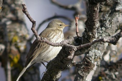
Pipit spioncelle en plumage d'hiver - Damien Combrisson - PNE FaunaThe water pipit
There's no point in searching for it: if it wants to, the water pipit can remain invisible, hovering against the blue of the sky. But it can make itself heard! It calls out its name « pi-pit-pipit-pipit-pipit » and suddenly, at the peak of its flight, it glides down towards the ground, its unfurled wings acting like a parachute, uttering a loud « piiiii » call. This call echoes from the rock bars which the Col Des Terres Blanche path winds around.
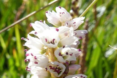
Renouée vivipare en fleur - Blandine Delenatte - PNE FloraThe alpine bistort
This persicaria is a hardy plant which withstands low temperatures and is capable of adapting to conditions in the montane zone right up to the alpine zone. Its reproduction is also adapted to the harsh environments in which it lives: while the white to pinkish flowers are grouped into a spike at the top of the inflorescence, small bulbils form underneath, along the spike. This persicaria is therefore viviparous, that is to say, it is capable of producing embryos ready to germinate, with no fertilisation.
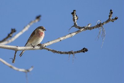
Linotte mélodieuse - Pascal Saulay - PNE FaunaThe common linnet
Trills, piping calls, loud and staccato sounds: the linnet's song seems random. Alpine pastures and ground dotted with scrub and wild grasses are its favourite high-altitude terrain. Here, it finds seeds to feed on and bushes in which it builds its nest, near to the ground and with no effort to conceal it. Might the linnet be careless? The mountains are a vital refuge for this species which is in decline due to reduced food resources: the small seeds of grasses which are regarded as weeds are eliminated from cultivated areas.
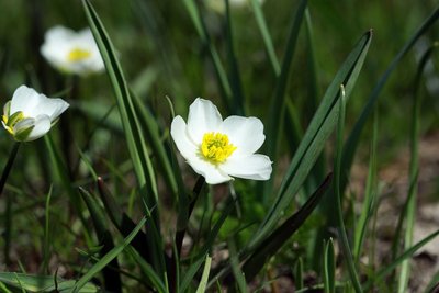
Fleur de renoncule des Pyrénées - Cédric Dentant - PNE FloraThe Pyrenean buttercup
When the snows have just melted on the high plateaux through which the Col des Terres Blanches path runs, the grass is turned a silky vibrant white by the petals of a multitude of small white buttercups. At the centre of a circle formed by five white petals, a string of yellow stamens surrounds the many green achenes which form a bristly cone of hooked "beaks".
Soldanelle des Alpes - Thierry Maillet- PNE FloraThe alpine snowbell
A cousin of the primrose, the fragile but tough snowbell heralds the return of fine weather. The snow bas barely melted yet here it is, its resilient violet bells poking up from the high-mountain grass, fringed like ballerinas' tutus. The round shape of its leaves, all grouped at the base of the stem, make them look rather like a penny coin, soldus in Latin, hence its French name soldanelle des Alpes.
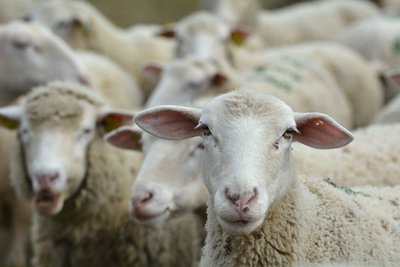
Troupeau de brebis - Mireille Coulon - PNE  Pastoralism
The plateau below the Col des Terres Blanches
The plateau below the Col des Terres Blanches is the August grazing ground for the Faravel flock which grazes the shores of the Lac du Fangeas in early summer. On the right, uphill of the path, a dry stone-built Jas, or sheepfold, is used by the shepherd as a store for the nets.
Miramelle des morraines - Mireille Coulon - PNE FaunaThe common mountain grasshopper
A witness of the ancient expansion of the glaciers, this grasshopper lives only above altitudes of 2,000 metres; it is an orophile (or mountain-loving) species. The male can easily be recognised by its black-striped yellow abdomen, its minuscule wings, its red upper hind legs and blue lower hind legs. Although bigger than the male, the female is less conspicuous with her greyish colouring. Moving about on foot holds no fear for the common mountain grasshopper, its Latin name Podisma pedestris making a double reference to walking. Not surprising, because its tiny wings make it incapable of flying! At this altitude, the summer is short-lived and the sexual organs develop before the wings.
Silène acaule - Mireille Coulon - PNE FloraThe moss campion
Commonly called the silène des glaciers (campion of the glaciers), it grows on rocky ground at altitudes of between 1,800 and 3,700 metres. In summer, it resembles clumps of moss dotted with tiny pink flowers. Its cushion-forming habit is a morphological as well as physiological adaptation, allowing it to withstand the extreme weather conditions at high altitudes. Inside the cushion, the climate is less harsh for the plant's biological activity and the dead leaves enrich with nutrients the solutions absorbed by the roots.
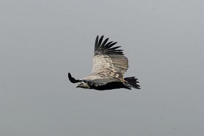
Vautour fauve en plein vol - Mireille Coulon - PNE FaunaThe griffon vulture
Its silhouette against the sky is unmistakable: rectangular wingspan, imposing and contrasting with long broad wings and a very short tail. With a wingspan of approximately 2.7 metres, it is a very big bird of prey which follows the herds in summer. Solely a carrion eater, it occupies a key place in the food chain by removing corpses quickly, limiting the risks of spreading bacteria. Griffon vultures are gregarious birds and it is rare to see one flying on its own in the skies over the Col des Terres Blanches!
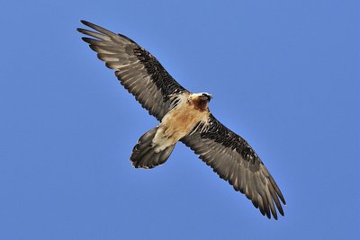
Plané du gypaète barbu - Mireille Coulon - PNE FaunaThe bearded vulture
This is one of the biggest birds in Europe. It is very noticeable with its 2.8-metre wingspan and its lozenge-shaped tail. The juveniles are rather dark-coloured and have broad wings while the adults have a light body and narrow wings. The orangey colour of their breasts comes from the baths they take in iron-rich waters. In captivity, the bearded vulture has a white body. Its diet, which is essentially made up of bones, has earned it the nickname « bone breaker ». In fact, when a bone is too big, it carries it high into the air and drops it onto rocky ground. Then, all it has to do is to ingest the scattered bone fragments, which are digested by its powerful gastric juices.
Source

Report a problem or an error
If you have found an error on this page or if you have noticed any problems during your hike, please report them to us here: