The Collet de la Salcette (trail route no. 10)
“When you leave the forest and enter the rather hidden little valley, going past Les Tenailles, you almost feel as if you are at the end of the world. Then you come to the Collet de la Salcette and you feel as if you are on top of it!“ Marie-Geneviève,park ranger at the Parc National des Écrins
Description
From the Le Courounba campsite, head for Le Pont du Rif at the bottom end of the village of Les Vigneaux and, from here, follow the road towards Briançon.
- 1.5 kilometres after leaving the village, take the path on the left leading to La Rourée and Bouchier. It leads uphill through a forest of Scots pines and oak trees before dropping gently and coming to a winding bend in the track leading to Bouchier.
- Follow the path on the left leading directly below the hamlet. Turn right and carry on along a forested track, heading due north towards La Bletonnée along a flat uphill section.
- After the few houses, take a steep path which follows the left-hand bank of the mountain stream La Combe, and crosses it further up. The slope becomes less steep and leads up through the north-facing combe to a grassy plateau where the Croix de la Salcette stands.
- The descent is along a steep path following the southern ridge.
- At a fork in the path, leave the ridge to descend directly to the right towards Le Périllas and Les Vigneaux. Lower down, the path comes to the pine forest again and culminates at the top end of the village. Make your way back to Le Pont du Rif and your starting point.
- Departure : Camping du Courunba, Les Vigneaux
- Arrival : Camping du Courunba, Les Vigneaux
- Towns crossed : Les Vigneaux and Saint-Martin-de-Queyrières
Altimetric profile
Recommandations
Before setting off, it is very important to check the opening periods for this route on the website: https://stationdetrail.com/fr/stations/le-pays-des-ecrins/parcours
Share your photographs on social networks with #stationdetrailecrins
Check weather conditions before setting off.
Rescue services contact details: Secours Montagne (Mountain Rescue): +33 (0)4 92 22 22 22 or 112
Show consideration for the work of farmers, livestock keepers and owners
Close all gates behind you
Take your litter home
Do not take shortcuts across pastureland
The trail routes are also suitable for walking
Information desks
Place de l'Eglise, 05340 Vallouise

Vallouise Park house
, 05290 Vallouise
Information, documentation, models, exhibitions, screenings, product sales and works of the Park. Guided tours for school, reservation required. The new Park House opened in Vallouise since June 1, and offers visitors an interactive permanent exhibition inviting to explore the area and its heritage. A temporary exhibition space will allow a renewed offer. Finally, the device is completed by an audiovisual room to organize screenings and conferences Free admission. All animations of the Park are free unless otherwise stated.
Transport
Public transport >> www.pacamobilite.fr
Consider car-sharing >> www.blablacar.fr
For more information, ask at the Tourist Information Office nearest to the trail starting point.
Access and parking
10 km from L'Argentière-La Bessée, take the D994E.
Parking :
Sensitive areas
Golden eagle
- Impacted practices:
- Aerial, , Vertical
- Sensitivity periods:
- JanFebMarAprMayJunJulAug
- Contact:
- Parc National des Écrins
Julien Charron
julien.charron@ecrins-parcnational.fr
10 points of interest
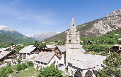
Eglise des Vigneaux - Blandine Reynaud - PDE  History
The village of Les Vigneaux
In spite of the altitude, the region's dry climate and the local growing conditions of limestone and sediments facing due south made the planting of grapevines possible as far back as the tenth century. The municipality owes its name to the presence of these vineyard operations, which were very significant in the late nineteenth century. The almost simultaneous appearance of the phylloxera aphid and the Briançon train, bringing wine from Provence, spelled the end of this activity here.
Vue sur le Massif du Montbrison - Office de tourisme Pays des Écrins  Panorama
The view over the Montbrison massif
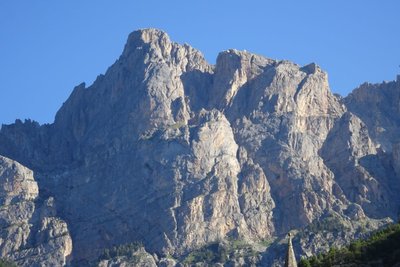
The path offers a beautiful overall view of the limestone massif of Montbrison, overlooking the hamlets of Pelvoux and including the Cime de la Condamine, the Tête des Lauzières, the Pic de Montbrison and the Tête d'Amont.
Damien Combrisson - Parc national des Écrins  Fauna
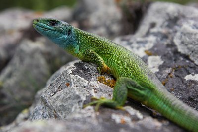
FaunaThe western green lizard
Very shy, this large lizard quickly takes refuge beneath a bush or stone, or among the tangled branches of a hedge when it senses danger. It is on average 30 cm in length and it is bright green slightly speckled with black. During the mating season, the male presents a bright blue colouring on his throat and on the sides of his head. It lives on sunny south-facing slopes, in uncultivated areas and forest edges, where it feeds primarily on insects.
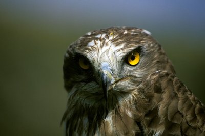
Le circaète Jean-le-Blanc - Marc Corail - Parc national des Écrins FaunaThe short-toed snake eagle
In March, this large brown bird of prey, brown on its upperside, white speckled with black on its underside and a dark head, returns from Sub-Saharan Africa where it has spent the winter. It feeds primarily on reptiles which its hunts in steppe or barren areas, derelict sites or stony terrain. It builds its nest in a pine tree where it will rear a single chick. It can often be seen hovering in the air, thirty or so metres above the ground, and then swooping down on its prey.
La chapelle Saint-Hippolyte de Bouchier - Office de tourisme Pays des Écrins HistoryThe hamlet of Bouchier
Bouchier is a small hamlet in the municipality of Saint-Martin-de-Queyrières, which has a few permanent inhabitants in spite of its relatively inaccessible location. Standing a little apart from the hamlet, on a promontory overlooking the Durance valley, the chapel of Saint-Hippolyte dates from the early sixteenth century. It was built against what used to be a hermit's cell, and contains frescoes some of which relate the miraculous cures performed by the saint. It drew ailing people who flocked here to seek his intercession.
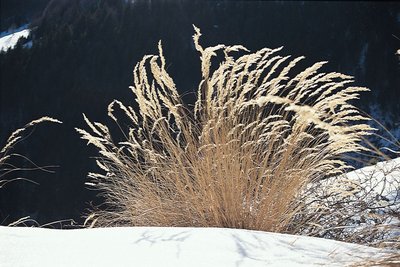
La calamagrostide argentée - Denis Fiat - Parc national des Écrins  Flora
FloraAchnatherum calamagrostis or silver spike grass
This member of the Gramineae family (now called Poaceae) forms large clumps on stony, dry and sunny ground. It grows in abundance here on the track embankment, taking advantage of the sunlight allowed through by the break in the forest. Its inflorescences reflecting silvery-gold glints are made up of flowerets with long edges. They create a very misty effect in the late summer when the plant is mature, forming large shimmering bouquets in the evening sunlight. .
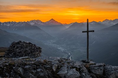
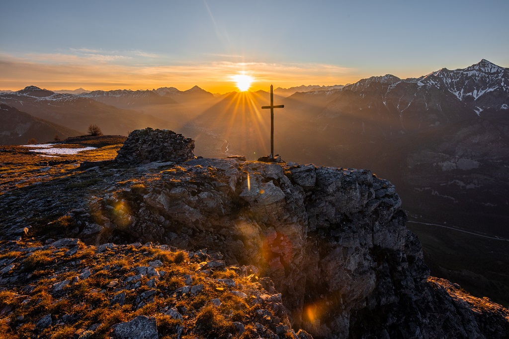
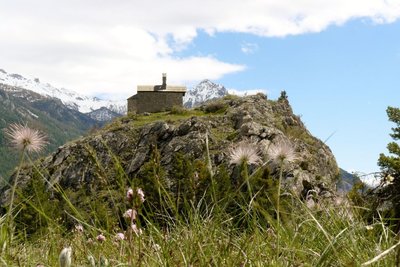
Lever de soleil à la Croix de la Salcette - Thibault Blais Photographie PanoramaThe Croix de la Salcette
The highlight of this trail, overlooked by the southern, colourful foothills of the Montbrison massif (Tête d'Aval, Tête d'Amont, Les Tenailles), the Croix de la Salcette offers both the gentleness of a vast alpine grassland and a splendid panorama of the upper reaches of the Durance valley.
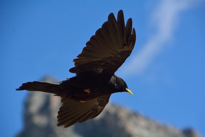
Chocard à bec jaune en vol - Mireille Coulon - Parc national des Écrins FaunaThe alpine chough
This small black corvid sports a yellow beak and red legs. It likes to fly in groups of several dozen or even several hundred individuals. Common in the mountains and a great acrobat, it can often be spotted whirling around cliffs or skimming over the alpine grasslands. It often hangs around picnics to gather up the crumbs!
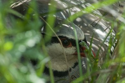
Perdrix batavelle - Mireille Coulon - Parc national des Écrins FaunaThe rock partridge
At the approach of intruders, rock partridges fly away with a great whirring of wings from the rocky ground where they had hitherto passed unnoticed. This bird favours south-facing slopes which are rocky and well exposed to the sun. During the mating season, at dawn the male produces an echoing, rasping and rhythmic call. It is a species in sharp decline.
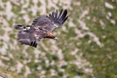
Aigle royal - Pascal Saulay - Parc national des Écrins FaunaThe eagles of the Tête d'Aval
Eagles can be seen gliding around the Tête d'Aval. In the hottest part of the day, they circle on the thermals rising above the limestone cliffs. Having gained height in this way, they can reach their hunting territory without having to flap their wings.
More information
Source

Report a problem or an error
If you have found an error on this page or if you have noticed any problems during your hike, please report them to us here: