
Le Lauzet circuit (trail route no. 8)
Pine, fir and larch trees, forest roads, meadows and a mountain stream all combine to make this a highly varied trail. On the way to the chalets of Le Lauzet, this circuit is brimming with a harmonious variety of landscapes!
Description
Facing away from the entrance to the lake campsite, turn right to go through the village of La Roche-de-Rame along the Rue Les Queyras. After going past the cemetery, continue to the right.
- Turn left. At the end of this track, at the D38 continue by turning right. A little further up, cross the bridge on the right. After the Bouchouse hydroelectric power station, turn left and take the path leading off to the right. Carry on along this path until you reach the Bel Pinet sector.
- At the Bel Pinet sector, take the path on the right to start the descent.
- As you approach the pink marble quarries, take the path on the left. This is a technical section. Then after a succession of hairpins, continue straight on towards Le Lauzet.
- At the chalets in Le Lauzet, turn left onto a forest road. At Le Giet, continue straight ahead on a path which is technical in places. This brings you to the vast open pasture area of Pré Chapelle.
- Take the track on the left running along the edge of a wood, the Bois du Sapet. In Le Puy, continue by taking the track on the right.
- Continue to the right. You pass a succession of hairpins and come to La Roche-de-Rame, through the Barthéou district.
- Departure : Camping du lac (lake campsite), La Roche-de-Rame
- Arrival : Camping du lac (lake campsite), La Roche-de-Rame
- Towns crossed : La Roche-de-Rame
Altimetric profile
Recommandations
Before setting off, it is very important to check the opening periods for this route on the website: https://stationdetrail.com/fr/stations/le-pays-des-ecrins/parcours
Share your photographs on social networks with #stationdetrailecrins
Check weather conditions before setting off.
Rescue services contact details: Secours Montagne (Mountain Rescue): +33 (0)4 92 22 22 22 or 112
Show consideration for the work of farmers, livestock keepers and owners
Close all gates behind you
Take your litter home
Do not take shortcuts across pastureland
The trail routes are also suitable for walking
 In mountain pastures, protection dogs are there to protect the herds from predators (wolves, etc.).
When I hike I adapt my behavior by going around the herd and pausing for the dog to identify me.
Find out more about the actions to adopt with the article "Protection dogs: a context and actions to adopt".
Tell us about your meeting by answering this survey.
Information desks
23 Avenue de la République, 05120 L'Argentière-La Bessée

Vallouise Park house
, 05290 Vallouise
Information, documentation, models, exhibitions, screenings, product sales and works of the Park. Guided tours for school, reservation required. The new Park House opened in Vallouise since June 1, and offers visitors an interactive permanent exhibition inviting to explore the area and its heritage. A temporary exhibition space will allow a renewed offer. Finally, the device is completed by an audiovisual room to organize screenings and conferences Free admission. All animations of the Park are free unless otherwise stated.
Transport
Public transport >> www.pacamobilite.fr
Consider car-sharing >> www.blablacar.fr
For more information, ask at the Tourist Information Office nearest to the trail starting point.
Access and parking
6.5 km from L'Argentière-La Bessée, take the N94.
Parking :
Sensitive areas
Short-toed snake eagle
- Impacted practices:
- Aerial,
- Sensitivity periods:
- MarAprMayJunJulAugSep
- Contact:
- Parc National des Écrins Julien Charron julien.charron@ecrins-parcnational.fr
6 points of interest
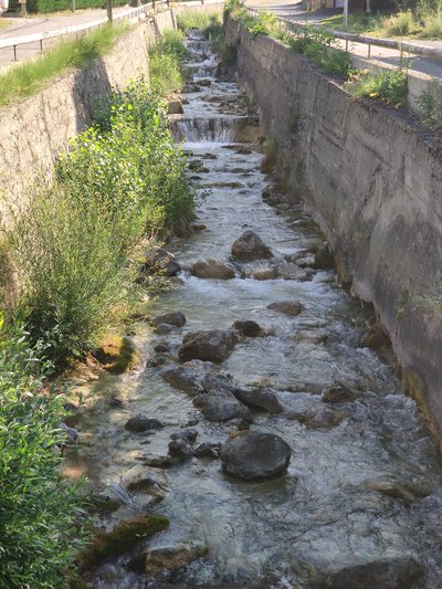
Torrent de Bouchouse - Office de tourisme du Pays des Écrins  Water
WaterBouchouse mountain stream
The Bouchouse mountain stream is fed by the Le Pansier and La Pisse mountain streams 1,900 metres above sea level. It crosses the municipality of La Roche-de-Rame, supplying it with water. This mountain stream then flows into the Durance below the municipality.
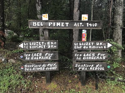
Bel Pinet - Office de tourisme du Pays des Écrins  History
Bel Pinet
Bel Pinet stands at 1,400 metres above sea level in the Bouchouse valley, in the municipality of La Roche-de-Rame. Bel Pinet, or Bel-Pinet, designates the slopes under the rocky cliffs of the Oumbras. It was once irrigated by the Bel Pinet Canal, which suggests that it used to be cultivated and would therefore have been less wooded. The term "Pinet" simply means a place planted with pines (Pinus in Latin). So Bel Pinet means a beautiful place planted with pines, or a beautiful pine wood.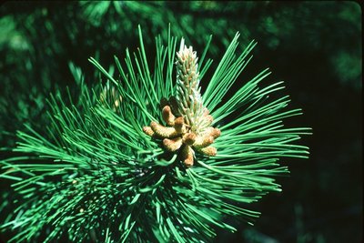
Pin sylvestre - Parc national des Écrins  Flora
FloraPine forest
The path runs through a forest of Scots pine, recognisable by its orangey trunk, especially at the top. This tree is very drought-resistant (it is very limey soil here) and can also withstand low temperatures. It is therefore found in large numbers in the intra-alpine valleys.
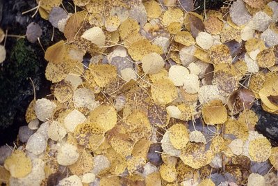
Daniel Roche - Parc national des Écrins FloraThe aspen wood
Here, a wood of aspen trees, with smooth greenish trunks and round, crenulated leaves, adopt magnificent autumn colours. The petiole («tail») of aspen leaves is flat and twisted and can therefore be caught by the slightest breath of air. This has the effect of making the foliage tremble, hence its French name bois de tremble!
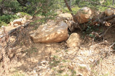
Marbre rose - Office de tourisme du Pays des Écrins HistoryThe Pink Marble of Combe Mounière
In the nineteenth century, there were four quarries in La Roche-de-Rame. They exploited deposits of metamorphosed limestone which was pink in colour. One of these, the Combe Mounière quarry, produced stone which was used in particular in the construction of the new Cathedral of Saint-Arnoux in Gap, between 1866 and 1904. When exposed to the elements, the surface of the limestone takes on a grey patina.
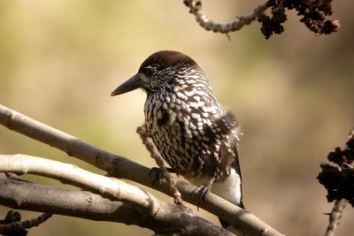
Cassenoix moucheté - Damien Combrisson - Parc national des Écrins  Fauna
FaunaThe spotted nutcracker
A harsh call sounds from the forest. A jay perhaps? No, a nutcracker, its cousin. With dark, white-spotted plumage, this bird's strong beak can break open hazelnuts (although not walnuts as suggested by its name in French, cassenoix (walnut breaker)) and in particular it can dissect Swiss pine cones in order to reach the pine nuts inside. It inhabits high forests. It buries Swiss pine nuts in the ground to store up food for the winter. When winter comes, it will find the pine nuts again even under a thick layer of snow. Those it forgets will germinate.
More information
Source

Report a problem or an error
If you have found an error on this page or if you have noticed any problems during your hike, please report them to us here: