Les Têtes via La Pignée (trail route no. 23)
On this vertiginous route, which offers exciting gradients, you will encounter lots of fellow outdoor sports enthusiasts. In fact, you will see kayakers at the white water stadium, climbers at the climbing site and on the Horloge via ferrata and also walkers, mountain bikers and other trailers as you ascend through the woods of La Pignée on your way to the highest point of the route: Les Têtes (2,044 m). From here, you will enjoy a breathtaking 360° panorama. You will then drop down to the Col de la Pousterle and on to the Fournel, and will end with a long downhill traverse back to your starting point.
Description
The circuit starts at the Les Écrins campsite in L'Argentière-la-Bessée. You will go past the white water stadium along the green route ("Voie Verte") and on to the industrial zone and the roundabout in the Avenue Charles de Gaulle
- At the roundabout, turn left, go through the railway line underpass and then turn right at the second roundabout, heading towards the Horloge des Hermes clock tower and Les Combettes
- Head left to La Blachière and then take a path running above the silver mines ("Mines d'Argent")
- After crossing the mountain stream L'Eychaillon, start a long ascent to the right along a magnificent single-track through the woods of La Pignée, heading towards Les Têtes
- When you reach Les Poutilles, head left to the highest point of the trail - Les Têtes (2,044 m) - and then retrace your steps, following the route in reverse. In Les Poustilles, head left to drop back down to the Lac des Sagnes and on to the Col de la Pousterle as far as the Champ Didier
- Cross the Fournel and then turn left to start a long traverse downhill towards Le Sapey and the Bois du Champ Pelbaud, in a pine forest
- Go right onto the north-facing slope ("Ubac") and then follow signs for Plan Léothaud
- Turn left, cross the local road and then the railway line. Then turn left again to follow the railway line to the Les Écrins campsite and your starting point
- Departure : Camping Les Écrins, L’Argentière-la-Bessée
- Arrival : Camping Les Écrins, L’Argentière-la-Bessée
- Towns crossed : L'Argentière-la-Bessée and Les Vigneaux
Altimetric profile
details.BAMwidget
Recommandations
Before setting off, it is very important to check the opening periods for this route on the website: https://stationdetrail.com/fr/stations/le-pays-des-ecrins/parcours
Share your photographs on social networks with #stationdetrailecrins
Check weather conditions before setting off.
Rescue services contact details: Secours Montagne (Mountain Rescue): +33 (0)4 92 22 22 22 or 112
Show consideration for the work of farmers, livestock keepers and owners
Close all gates behind you
Take your litter home
Do not take shortcuts across pastureland
The trail routes are also suitable for walking
Information desks
23 Avenue de la République, 05120 L'Argentière-La Bessée

Vallouise Park house
, 05290 Vallouise
Information, documentation, models, exhibitions, screenings, product sales and works of the Park. Guided tours for school, reservation required. The new Park House opened in Vallouise since June 1, and offers visitors an interactive permanent exhibition inviting to explore the area and its heritage. A temporary exhibition space will allow a renewed offer. Finally, the device is completed by an audiovisual room to organize screenings and conferences Free admission. All animations of the Park are free unless otherwise stated.
Transport
Public transport >> www.pacamobilite.fr
Consider car-sharing >> www.blablacar.fr
For more information, ask at the Tourist Information Office nearest to the trail starting point >> www.paysdesecrins.com
Access and parking
16 km from Briançon, take the N94.
Parking :
Sensitive areas
Peregrine falcon
- Impacted practices:
- Aerial, Vertical
- Sensitivity periods:
- FebMarAprMayJun
- Contact:
- Parc National des Écrins
Julien Charron
julien.charron@ecrins-parcnational.fr
Short-toed snake eagle
- Impacted practices:
- Aerial,
- Sensitivity periods:
- MarAprMayJunJulAugSep
- Contact:
- Parc National des Écrins
Julien Charron
julien.charron@ecrins-parcnational.fr
Short-toed snake eagle
- Impacted practices:
- Aerial,
- Sensitivity periods:
- MarAprMayJunJulAugSep
- Contact:
- Parc National des Écrins
Julien Charron
julien.charron@ecrins-parcnational.fr
Short-toed snake eagle
- Impacted practices:
- Aerial,
- Sensitivity periods:
- MarAprMayJunJulAugSep
- Contact:
- Parc National des Écrins
Julien Charron
julien.charron@ecrins-parcnational.fr
Short-toed snake eagle
- Impacted practices:
- Aerial,
- Sensitivity periods:
- MarAprMayJunJulAugSep
- Contact:
- Parc National des Écrins
Julien Charron
julien.charron@ecrins-parcnational.fr
12 points of interest
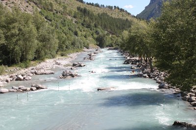
Stade d'eau vive - Office de tourisme du Pays des Écrins  Water
WaterThe white water stadium
As part of its restructuring after the closure of the industrial site, the town of L'Argentière-la-Bessée opted for sports tourism, exploiting the natural elements present on the site, that is to say, water. Standing at the beginning of the longest navigable section of the Durance river, in 1993 the municipality decided to establish itself as a major white water centre by creating this stadium which covers a 400-metre stretch. So thanks to its reputation and its ideal situation, every year this stadium hosts several elite competitions at national and international level.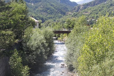
Le Fournel - Office de tourisme du Pays des Écrins WaterThe Fournel
The source of the Fournel rises in the Fournel valley, in the heart of the Parc National des Écrins, and flows into the Durance near the white water stadium. It is known as a high alpine canyon offering lots of sport and leisure possibilities, and is the most popular in the Haut Val Durance. It is ideal for an introduction to vertical activities, in particular thanks to the presence of several jumps, toboggan runs and rappel sites. Access is authorised from April to October and is regulated because it is located upstream from an EDF water intake, which presents a real hazard.
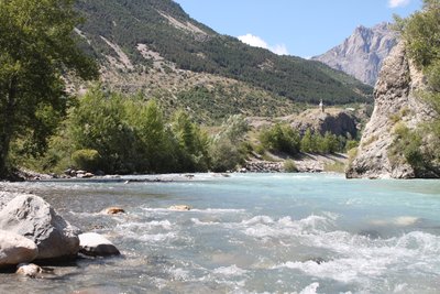
La Durance - Office de tourisme du Pays des Écrins WaterThe Durance
The Durance is the biggest river in Provence. Its source rises in the municipality of Montgenèvre at an altitude of 2,390 metres, and it flows down to meet the Rhône to the south of Avignon. This is a "pluvio-nival" river, that is to say, its flow depends on the natural addition of water due to snowmelt and rainfall. It thus constitutes a real playground for kayakers from across Europe.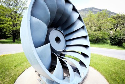
La turbine Francis - Jan Novak Photography  History
The Francis turbine
The American James Francis developed the Francis turbine between 1849 and 1855. It is a “àreaction” turbine suitable for medium-sized waterfalls (with a water head of between 15 and 500 metres). The water enters the turbine and then circulates between the turbine blades, which are fixed, while the inner wheel is mobile. The pressure at the wheel intake is greater than the pressure at the outlet.
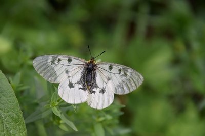
Le semi-apollon - Mireille Coulon - Parc national des Écrins  Flora
FloraThe Apollo
This large white butterfly decorated with black marks and red dots, is common in warm areas where stonecrops and houseleeks grow, as these are host plants for its caterpillars. It remains common in the Alps, but is much rarer elsewhere. In fact, it is a protected species. Its movement to higher altitudes has been observed, in line with climate warming, because its eggs, which it lays on plants in summer, need a certain number of days of freezing temperatures in winter in order to hatch.
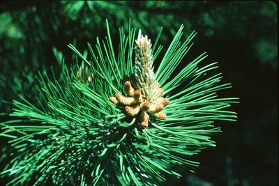
Le pin sylvestre - Parc national des Écrins FloraThe Scots pine
The path first runs up through a forest of Scots pines, a tree identifiable by its salmon-coloured bark, especially at the top, and its needles arranged in pairs. It is the typical tree of warm south-facing slopes in the montane zone of intra-alpine valleys.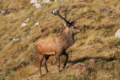
Cerf - Telmon Jean-Philippe - Parc national des Écrins  Fauna
FaunaThe deer
Deer are well-established across the Pays des Écrins. You can spot clues as to its presence: hoof prints or droppings, often in little piles. The stag loses his antlers at the end of winter (February-May) and they regrow up to the end of August. They reach full development before the rutting season (September), when you can hear the rutting call. The doe has no antlers.
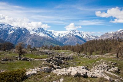
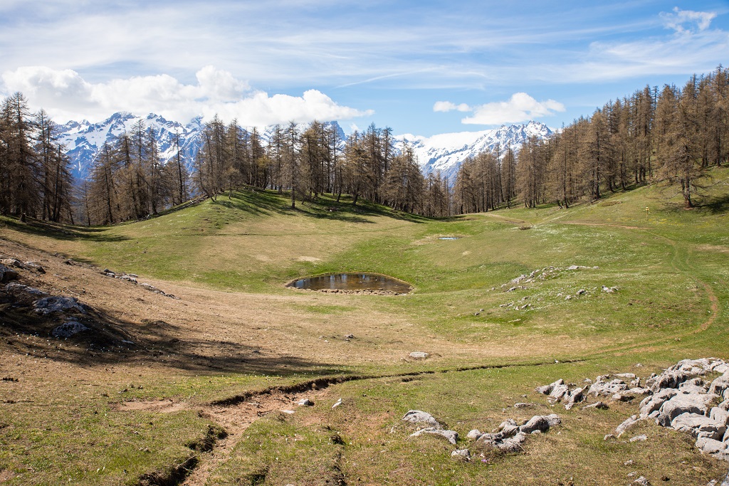
Les Têtes - Thibaut Blais  Panorama
The Les Têtes belvedere
This belvedere is worth the diversion, not only for its unrestricted panorama over the Fournel and Durance valleys but also for the place itself, with its sparse mature larches and the bare limestone scored with small fissures. These were created by the erosion of the rock by cold snowmelt waters or rain.
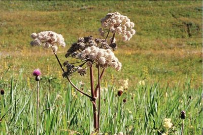
L'angélique sylvestre - Bernard Nicollet - Parc national des Écrins FloraThe wild angelica
On the edges of seepage areas, the wild angelica grows. This is a tall umbellifer (the Apiaceae family) with blush white flowers and a hollow purplish stem. It is a cousin of garden angelica which grows in Northern Europe and is cultivated for its medicinal and culinary properties. The stem, the petiole (the «tail») and the leaf sheath can be candied.
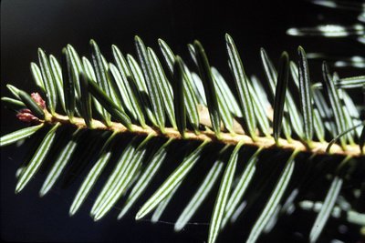
Aiguilles de sapin blanc - Parc national des Écrins FloraThe silver fir
A few coniferous trees, including the fir, are mixed in among the deciduous trees. The fir thrives on this north-exposed slope, called the ubac, because it cannot tolerate drought. Its flat needles are arranged on either side of the boughs rather than all the way around them, which distinguishes it from the spruce. They have two white stripes on their undersides. Its elongated cones stand upright, rather than hanging downwards.
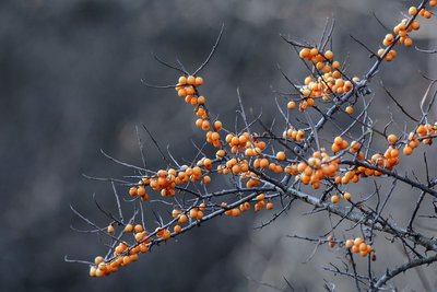
Baies d'argousier - Mireille Coulon - Parc national des Écrins FloraThe sea-buckthorn
Here and there, you come across a bush with narrow leaves which are green on their upper sides and silvery-grey underneath. Take care, the branches are spiky! In autumn, it produces acidic bright orange berries. They are very rich in vitamin C and are best as a syrup or marmalade. It is a pioneer species which colonises alluvial soils in sunny situations. It has also been used by the Mountain Terrain Restoration service to stabilise slopes prone to water runoff.
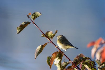
Le pouillot véloce - Mireille Coulon - Parc national des Écrins FaunaThe common chiffchaff
When spring arrives, a relentless «cheep, cheep» echoes around the forest. The singer is a small bird with a greenish grey and yellowish-white back, the common chiffchaff. Like other inconspicuous birds, the male has every incentive to make himself heard if he wants to attract the attention of a female! They are migratory and live almost anywhere where there are trees and bushes.
More information
Source

Report a problem or an error
If you have found an error on this page or if you have noticed any problems during your hike, please report them to us here: