2. From Bouchier to Vallouise
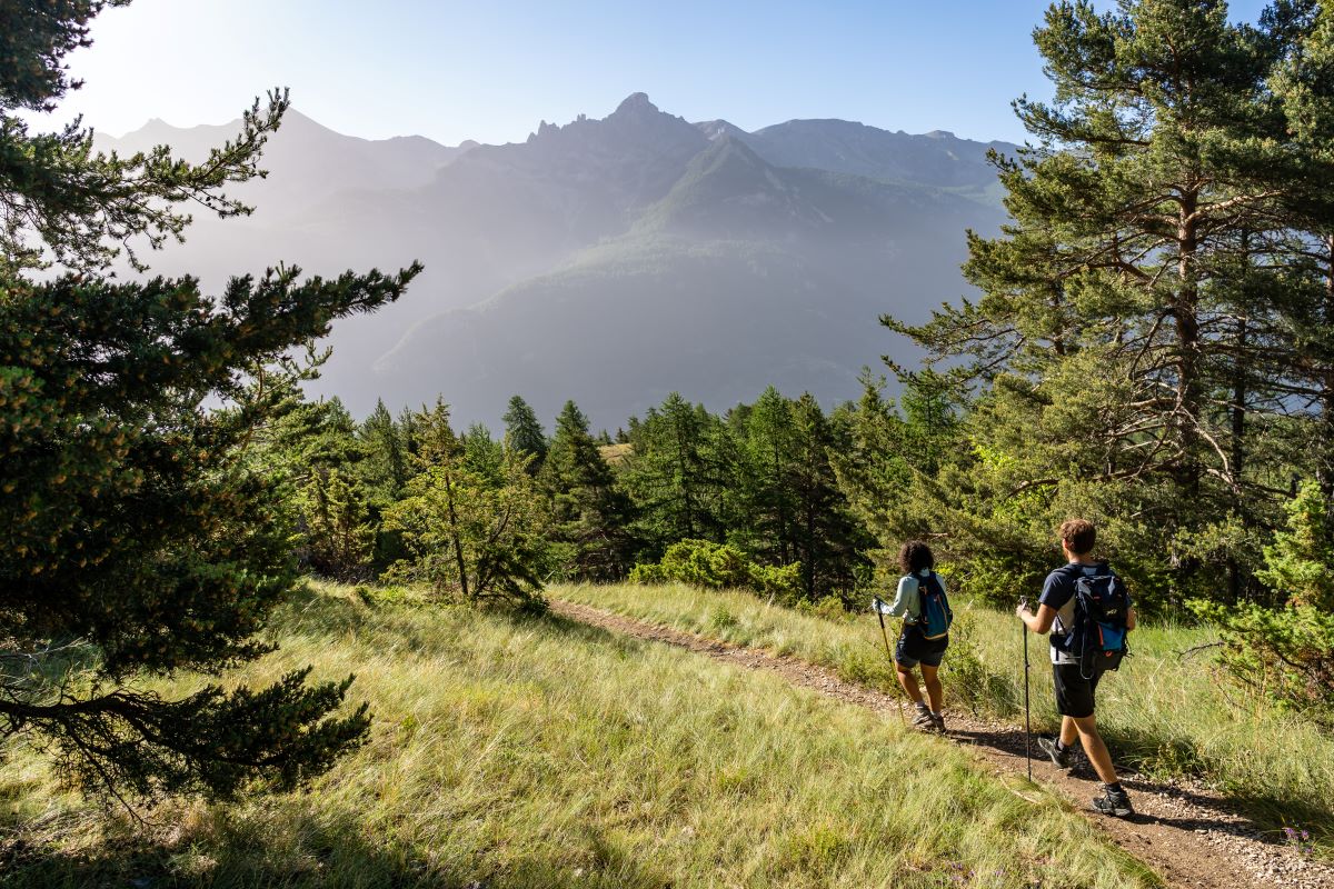
Hemmed in by the Montbrison massif, as you round a bend in the path you come face to face with the Vallouise valley and the delights in store over the coming days: the village of Vallouise, the Ailefroide valley dominated by Mont Pelvoux, the resort of Puy-St-Vincent, the Col de la Pousterle and more besides...
Description
As you set off from the car park in Bouchier, leave the track leading to the Gîte le Pas du Loup on your left and take the small path that rises through the base of the valley over a terrain of large boulders. At the first fork, continue straight on. A few metres further on (GR waymark) follow the sign to Bois du Clot. The path climbs up to a spring (large boulder) and then follows the contour line. The path, which turns into a track, is rather vertiginous in places. At the next intersection, head towards Rocher les Rouilles.
1. From here, leave the balcony path to start the descent down to Les Vigneaux. At subsequent intersections, follow the downhill path (Les Vigneaux) (GR waymark). When you reach Barthalay (DFCI (forest fire defence agency) tanks), take the track on the right (Les Vigneaux) following its twists and turns until you come to an intersection with a sign to Les Parchers. Follow this sign and ford the Rif Cros mountain stream.
2. The route sets off northward towards Vallouise. After the mountain stream, take a path on the right (Les Parchers). You come to a track on the left, which you follow. At the intersection 50 metres beyond a hairpin bend, take the path on the left (Les Parchers). The track turns into a path with a superb view over the valley. When you reach Le Parcher, follow the paved road uphill (Bois Noir) for a few metres and then bear left towards a charming building with wooden balconies. Pass below the building and follow the path which runs uphill to the left of the building. Follow the steep narrow path, continuing straight ahead until you reach 1,320 metres altitude where you come to an old irrigation ditch which you follow left. At the next intersection (hairpin), take the track leading to the left (Vallouise). When you reach the gate, take the uphill path, ford the Champarie stream and then take a small path running downhill to the left (Vallouise).
3. From here, continue downhill to the La Casse housing estate and Vallouise. At the next intersection, head towards Vallouise. When you come to the houses, take a small path that runs below a house. Before the pylon, turn right towards a large meadow down the hill. You come to a wide path which you follow right for a few metres, then take a path on the left that leads to the large meadow. You follow this path, which turns into a track, which takes you through the meadows to the cemetery and on to the centre of Vallouise.
- Departure : Bouchier
- Arrival : Downtown Vallouise
- Towns crossed : Saint-Martin-de-Queyrières, Les Vigneaux, and Vallouise-Pelvoux
Altimetric profile
Recommandations
Just after leaving Bouchier, there is a short vertiginous section but it does not present any real difficulty.
Two ford crossings (Torrent de Rif Cross and Champarie stream); exercise caution in stormy weather.
Information desks
Place de l'Eglise, 05340 Vallouise

Vallouise Park house
, 05290 Vallouise
Information, documentation, models, exhibitions, screenings, product sales and works of the Park. Guided tours for school, reservation required. The new Park House opened in Vallouise since June 1, and offers visitors an interactive permanent exhibition inviting to explore the area and its heritage. A temporary exhibition space will allow a renewed offer. Finally, the device is completed by an audiovisual room to organize screenings and conferences Free admission. All animations of the Park are free unless otherwise stated.
Sensitive areas
Short-toed snake eagle
- Impacted practices:
- Aerial,
- Sensitivity periods:
- MarAprMayJunJulAugSep
- Contact:
- Parc National des Écrins
Julien Charron
julien.charron@ecrins-parcnational.fr
7 points of interest
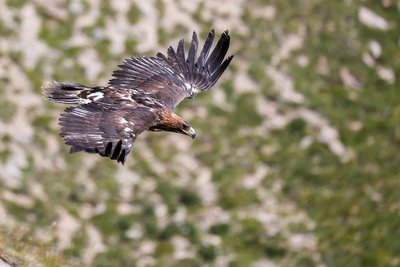
Aigle royal - Pascal Saulay - Parc national des Écrins  Fauna
FaunaThe eagles of the Tête d'Aval
Eagles can be seen gliding around the Tête d'Aval. In the hottest part of the day, they circle on the thermals rising above the limestone cliffs. Having gained height in this way, they can reach their hunting territory without having to flap their wings.
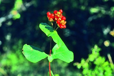
Le chévrefeuille d'Étrurie - Bernard Nicollet - Parc national des Écrins  Flora
FloraEtruscan honeysuckle
Etruria was the territory of the Etruscans, in the area of present-day Tuscany. Although this honeysuckle does not grow only in Tuscany, it is Mediterranean, however, and only grows naturally in the wild in the southern half of France. Being a plant that needs warmth, it does not grow at altitude, except here where the south-facing slopes are particularly dry and warm. Its large pink and yellow flowers are highly perfumed.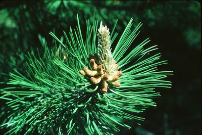
Aiguilles de pin sylvestre - Parc national des Écrins FloraOn the south-facing slope, pine forest
The track passes through a forest of Scots pines, mixed with some downy oak trees. It is a forest typical of those found in the lower south-facing slopes (those exposed to the sun) in the intra-alpine valleys.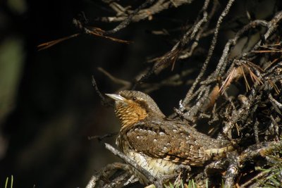
Le torcol - Damien Combrisson - Parc national des Écrins FaunaThe northern wryneck
In the spring, an odd song can be heard among the old trees in the orchard, a loud song similar to that of the green woodpecker, only slower. It is that of the northern wryneck. This bird owes its name to the extreme way it extends and twists its neck when it feels threatened. Its French name torcol fourmilier is a reference to the fact that it feeds on ants (fourmils in French). Difficult to spot because its plumage merges into the colour of the tree trunks, it gives its presence away by its song when it returns from its migration.
Aiguilles de pin sylvestre - Christian Baïsset - Parc national des Écrins FloraThe Scots pine
A long trunk that is reddish-brown towards the top, sparse foliage, grey-green needles grouped in pairs... It has to be the Scots pine. Happy in poor soil, this softwood tree can withstand below-zero temperatures as well as summer droughts, and so it is very common in intra-alpine valleys with a continental climate, like the Vallouise.
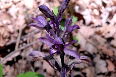
La limodore à feuilles avortées (limodorum abortivum) - Mireille Coulon - Parc national des Écrins FloraThe violet bird's-nest orchid
In the pine forest undergrowth stands a large, completely purple orchid. It has no leaves, just a few whitish scales on the stem. Lacking chlorophyll (the green plant pigment which plays a role in photosynthesis, the process that allows the production of organic matter), it lives as a parasite on tree roots.
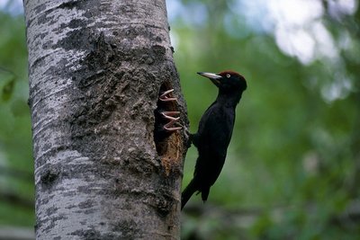
Pic nir et ses petits au nid - Robert Chevalier - Parc national des Écrins FaunaThe black woodpecker
Sporting a black cap, the black woodpecker is the biggest of the woodpecker family. Wary and solitary, it is difficult to spot, but its strident calls give its presence away. It feeds mainly on ants and insects living in dead trees, which it extracts by hammering into the wood. It hollows out a nest hole in trees. Once the young have left the nest, it may be taken over by owls or forest-dwelling bats.
details.BAMwidget
Source

Report a problem or an error
If you have found an error on this page or if you have noticed any problems during your hike, please report them to us here: