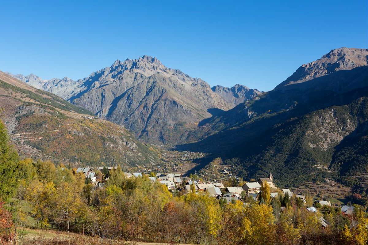
From Ailefroide to Puy-Saint-Vincent 1400
Description
- You meet the Ailefroide road. Go through the tunnel, cross the bridge and stay on the road for 150 metres, then take the track on the left. Stay on the narrow paved road on the right-hand bank of the mountain stream (Le Sarret) until you reach the car park at the Pelvoux resort. Go past the swimming pool and stay on the paved road that hugs the river. After the last houses, stay on the wide track along the Gyr. At the next intersection, take the uphill track towards Vallouise.
- The Gyr riverbank is left behind as you rise uphill towards Puy Aillaud. On the hairpin bend, take the path on the left. After 50 metres, turn right (Puy Aillaud).
- In Puy Aillaud, follow the posts in the Puy Aillaud meadow. Join the road and head towards Vallouise past the chapel. After leaving the village, a few dozen metres along the road take the path running down on the left (Vallouise). When you come to the chapel, do not go straight on but instead follow the road on the left. After the hairpin bend, take a narrow (steep!) path on the left (trail no. 19). At the first houses, follow the paved road (downhill), cross the Entre-les-Aygues road and take a small path opposite which leads to the village square.
- In Vallouise, go across the square and along the street opposite which leads past the bread oven. At the intersection ("Vallouise 1,170"), follow the sign to Pont des Fontaines. The track runs through the meadows and joins the track running along the left-hand bank of the Onde. Follow this track until you reach the Pont des Fontaines (2nd bridge). Cross the bridge and turn left. After 250 metres, you have the option of a there-and-back detour to the La Pissette waterfall (20 minutes). Make your way back onto the path running along the left-hand bank of the Onde, to the bridge (Pont Gérandoine).
- Cross the bridge and continue along the road to the junction with the D4, where you follow the sign for Puy St Vincent. Just as you are coming out of the first hairpin bend, take the track on the left (Champ Clément, GR waysign). At the following junctions, always follow signs for Les Alberts (GR). When you reach the main road, skirt around the SDIS (fire service) building (pedestrian walkway, metal steps). Then take the paved road on the left as far as St Roch..
- Departure : Ailefroide
- Arrival : Puy-Saint-Vincent 1400
- Towns crossed : Vallouise-Pelvoux and Puy-Saint-Vincent
Altimetric profile
Recommandations
After Puy Aillaud and the chapel, there is a very steep descent offering little grip in dry weather and slippery if the ground is wet).
Information desks
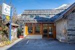
110 route des Alberts - Station 1400, 05290 Puy Saint Vincent 1400 m
Sensitive areas
Golden eagle
- Impacted practices:
- Aerial, , Vertical
- Sensitivity periods:
- JanFebMarAprMayJunJulAug
- Contact:
- Parc National des Écrins
Julien Charron
julien.charron@ecrins-parcnational.fr
Golden eagle
- Impacted practices:
- Aerial, , Vertical
- Sensitivity periods:
- JanFebMarAprMayJunJulAug
- Contact:
- Parc National des Écrins
Julien Charron
julien.charron@ecrins-parcnational.fr
19 points of interest
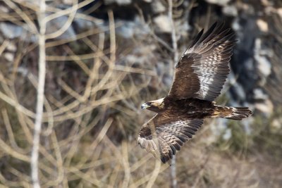
L'aigle royal - Pascal Saulay - Parc national des Écrins  Fauna
FaunaThe golden eagle
A pair of eagles lives in the Ailefroide valley. Every pair has a very large hunting territory, which means there can be no more than one pair in a small valley of this size. This pair has built several eyries in the cliff walls around Ailefroide: just one is occupied every year, after a few refurbishments. The eyries are located at the lower altitudes of the hunting territory, so that the eagles can easily bring heavy prey back to the eaglet.
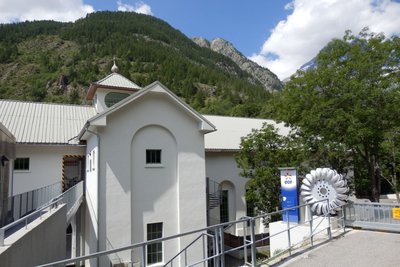
L'usine des Claux - Office de tourisme Pays des Écrins  Vernacular heritage
The penstock pipe
This penstock pipe carries water to the Le Claux hydroelectric power plant, located just below here, which exploits the water from the Les Écrins massif. The power plant was inaugurated in 1932. At the time, the electricity generated was primarily used to power the aluminium factory located in L'Argentière-La Bessée.
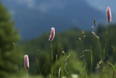
Bistorte - Parc national des Écrins  Flora
FloraCool meadow
The track passes through a meadow area, which is categorised as "cool" because of the ground water content there. A botanist quickly recognises this type of meadow through its range of plant life and, in particular, the presence of bistort, a bottle brush-shaped plant bearing a dense spike of tiny pink flowers at the top of its stem. It is also called langue de boeuf ("ox tongue" in English) because of the shape of its leaves.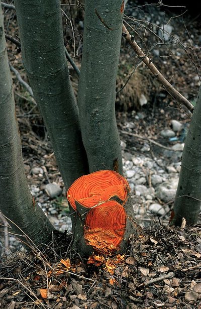
L'aulne blanc - Nicollet Bernard - Parc national des Ecrins FloraThe grey alder
In the valleys of the Alps and the Jura, the grey alder often grows in place of the black alder, present in many parts of France. Like its cousin, it grows on riversides and plays an important role in stabilising the banks. If it is cut down, its wood is bright orange in colour. But why cut it down?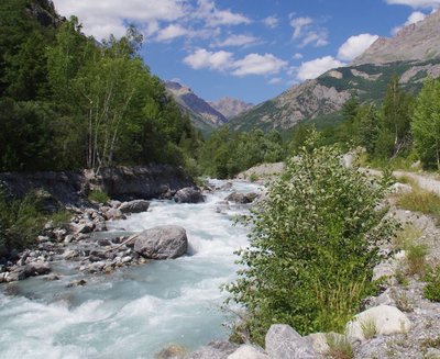
Le Gyr - Office de tourisme du Pays des Écrins  Water
WaterThe Gyr
Humans are decidedly bizarre animals: they build, knock down and start again. To protect the new infrastructures of Pelvoux, the Gyr was dammed. But, not able to flow as it did before, it deepened its bed, thus placing the foundations in danger of damage. And so works were carried out to widen its bed, allowing it to flow more naturally. This is also more favourable for biodiversity, as well as protecting the developed urban areas.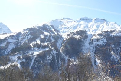
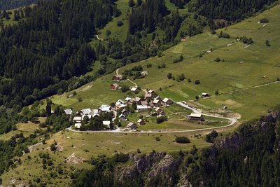
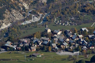
Vue sur la station de Pelvoux-Vallouise - Pelvoux Office de tourisme du Pays des Écrins Vernacular heritageThe ski resort of Pelvoux-Vallouise
The route first leads through the small ski resort of Pelvoux-Vallouise, built in 1982. Very family-focused, in winter it's the ideal place for young children to learn to ski, with small lifts lower down, while their big brothers and sisters can ski higher up.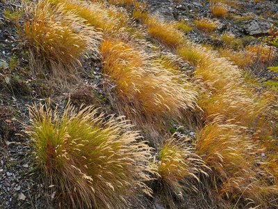
Le calamagrostide argentée - Nicolas Marie-Geneviève - Parc national des Écrins FloraSilver spike grass
A grass grows in large clumps on the embankment: silver spike grass. It is adapted to stony, dry and sunny ground. Its inflorescences reflecting silvery-gold glints create a beautiful effect, but they are particularly noticeable in the late summer, when it forms large shimmering bouquets in the evening sunlight.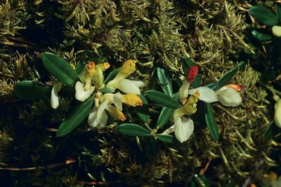
Polygale petit buis - Jean-Pierre Nicollet - Parc national des Écrins FloraThe shrubby milkwort
The shrubby milkwort grows in the undergrowth. This creeping sub-shrub has glossy oval leaves, similar to box leaves. The flowers are white and orangey yellow. Common in the Alps, it grows in open woods and dry forests.
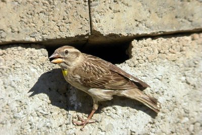
Le moineau soulcie - Damien Combrisson - Parc national des Écrins FaunaThe rock sparrow
A little flock of rock sparrows can often be spotted around Puy Aillaud. This large sparrow earned its French name moineau soulcie, (sourcil meaning eyebrow) because it has a large white eye-stripe. It also has a dark head, a brown back with white stripes, and a white breast and underside striped with light brown. It has a small yellow throat spot, often not visible. It is a year-round resident.
Hameau de Puy Aillaud - Jean-Philippe Telmon - Parc national des Écrins  History
The hamlet of Puy Aillaud
Puy Aillaud is a permanently inhabited hamlet and the highest in Vallouise (1,580 m). This hamlet has preserved some beautiful traditional houses.
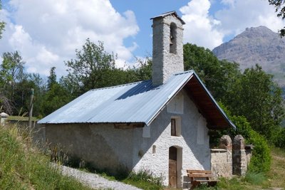
La chapelle Saint-Jean - Office de tourisme Pays des Écrins HistoryThe chapel of Saint-Jean
Surrounded by a cemetery and with a bench installed to the front of its façade, this pretty little seventeenth century chapel has an air of peaceful tranquillity. Maybe to sit and watch the trail runners?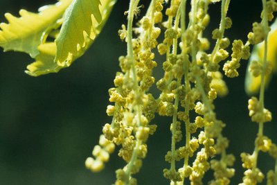
Chêne pubescent - Parc national des Écrins FloraThe downy oak
The route leads down a warm slope, where the downy oak reigns supreme. It is a small oak tree with a twisted growth habit and with marescent leaves, that is to say, they dry out in the autumn but remain on the tree all winter. It is called "downy" because the young branches, buds and sometimes the undersides of its leaves are covered in a fine down. It is a tree that grows happily on the warm dry slopes.
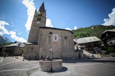
Place de l'Église - Thibaut Blais HistoryThe church in Vallouise
The church of Saint-Étienne dates from the fifteenth and sixteenth centuries. Inside is an altarpiece and a tabernacle in gilded wood dating from the eighteenth century, together with come mural paintings. Not far from the church stands the late sixteenth-century Chapel of the Penitents with a nineteenth-century painted facade.
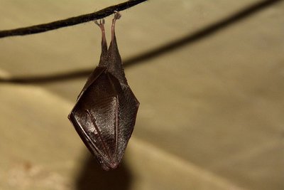
Petit rhinolophe enveloppé dans ses ailes - Mireille Coulon - Parc national des Écrins FaunaThe lesser horseshoe bat
In summer, bats take up residence in the church roof. The species living here is the lesser horseshoe bat, which has been in serious decline over recent decades. Every year, the mothers return after hibernating in caves and each one gives birth to one bat pup. Bats are insectivore mammals threatened by the insecticides used on farmland and on wooden structures and the loss of their hunting habitats and roosts, among other things. They are all protected.
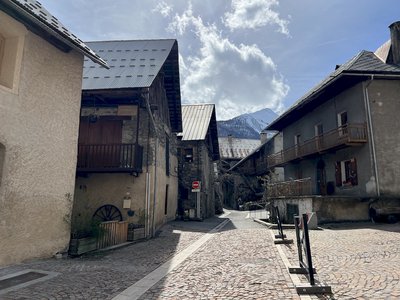
Rue de Champ de Ville - Pierre Nossereau  Architecture
Vallouise
Multi-storey houses - typical of the architecture in the valley in the seventeenth and eighteenth centuries - stand on the old village street. The ground floor was reserved for animals, the first floor for habitation and the upper floors for grain storage. People moved from one floor to another by means of balconies interconnected by a staircase. Many of these balconies are arcaded with stone columns. This type of arcaded balcony is found throughout the valley.
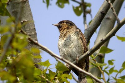
Torcol fourmilier - Damien Combrisson - Parc national des Écrins FaunaThe northern wryneck
The old trees in the orchard are home to the northern wryneck. It has a loud song, rather like that of the green woodpecker, only slower. This bird owes its name to the extreme way it extends and twists its neck when it feels threatened. Its French name torcol fourmilier is a reference to the fact that it feeds on ants (fourmils in French). Difficult to spot because its plumage merges into the colour of the tree trunks, it gives its presence away by its song when it returns from its migration.
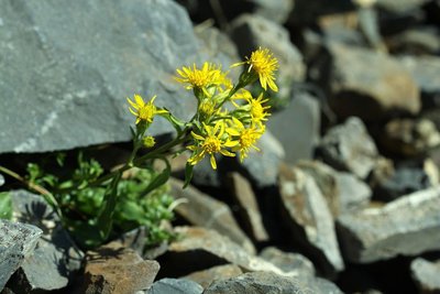
Petite verge d'or - Cédric Dentan - Parc national des Écrins FloraThe great goldenrod
In damp spots on the edge of the track, swathes of tall plants grow. It forms great plumes of tiny yellow plants. The great goldenrod, still known as the tête d'or or "head of gold" is a plant native to North America and introduced into Europe in the eighteenth century as an ornamental. Since then, it has colonised a large are of Europe and in some places it even competes with the local flora.
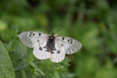
Le semi-apollon - Mireille Coulon - Parc national des Écrins FaunaThe clouded Apollo
This butterfly with hyaline (glass-like) translucent white wings, marked with two black spots, flutters around the clearing or the edges of the forest, where the host plants of its caterpillars grow: the corydalis. Although abundant locally, it is nevertheless a species in sharp decline and is protected.
Vue sur Puy Saint Vincent - Christophe Albert - Parc national des Écrins HistoryThe Sentier du Facteur - the postman's path
In former times, the postman would take this path every day: He would set out from Vallouise, deliver letters in Puy-Saint-Vincent and drop back down to Vallouise, stopping at the hamlets of Parcher on the way. In the winter, when the snow was too deep, the Traversouires (the inhabitants of Puy-Saint-Vincent) donned their snowshoes and wielded their shovels to clear the postman's path down to Vallouise.
details.BAMwidget
Source

Report a problem or an error
If you have found an error on this page or if you have noticed any problems during your hike, please report them to us here: