3. From Mouterres to L'Alpe de Villar d’Arène (stage of the GR 54)
A breathtaking day, more for the panorama, with the Meije in the background, than for technical difficulty. Our morning setting is the Emparis alpine pastures, before we move on to the charming villages of Chazelet and Les Terrasses. In the afternoon we walk through the Villar d'Arène mountain pastures, the paradise of marmots and chamois, at the foot of the Grande Ruine and the summit of the Agneaux. An idyllic place to spend the night.
Description
Go back to the confluence of the mountain streams and take the footpath to the right (GR54), which descends gently to Col de Souchet (2 365 m). The first footpath on the right leads to the Lérié and Noir Lakes (not on the GR footpath), which it would be a pity to miss. A looped circuit brings you back to the GR 54 (add one hour). Cross the Rifs (streams) of Caturages and Galan at the foot of Serre-Bernard and pass above the ruins of Pré Veyraud.
- Walk under the Plateau buttonlift and pass the footpath leading to Clot Raffin. Continue on down the footpath, which twists and turns steeply as far as the bridge over the Gua mountain stream (1 735 m).
- The right-hand road leads to Le Chazelet. Cross the village and follow the D33.
- Just after the oratory and the Perchoir, take the footpath leading to Les Terrasses (1 776 m).
- At the village church, take the footpath leading to La Grave (1 470 m). Then, as you leave the village (to the east), follow the road to the right leading to the campsite after going through La Grave.
- The road crosses the River Romanche soon after. After the bridge (1 456 m), take the footpath on the left, then, 100m further on, again take the left-hand footpath. Behind Les Vernois chalet, the footpath rises alongside the stream, then passes over it. Walk down towards Bois de la Chal d'Outre as far as the bridge facing Villar d'Arène (1 650 m). Walk along the left bank of the Romanche as far as the Brebis Bridge (1 662 m) and follow the road to the right as far as the gîte.
- Cross Arsine bridge (1 667 m), pass the lake on the right and continue on to the summer car park. The valley grows narrower and the footpath climbs upwards after the Colombié stream to reach the mountain pastures. Pass the Crevasses footpath that comes from Col du Lautaret, go past a weather station and you will arrive along the footpath on the right at the Alpe de Villar d'Arène refuge (2 079 m).
- Departure : Les Mouterres, Mizoën
- Arrival : Alpe de Villar d’Arène, Villar d’Arène
- Towns crossed : Mizoën, La Grave, and Villar-d'Arêne
Altimetric profile
Recommandations

Sensitive areas
Golden eagle
- Impacted practices:
- Aerial, , Vertical
- Sensitivity periods:
- JanFebMarAprMayJunJulAug
- Contact:
- Parc National des Écrins
Julien Charron
julien.charron@ecrins-parcnational.fr
Golden eagle
- Impacted practices:
- Aerial, , Vertical
- Sensitivity periods:
- JanFebMarAprMayJunJulAug
- Contact:
- Parc National des Écrins
Julien Charron
julien.charron@ecrins-parcnational.fr
Golden eagle
- Impacted practices:
- Aerial, , Vertical
- Sensitivity periods:
- JanFebMarAprMayJunJulAug
- Contact:
- Parc National des Écrins
Julien Charron
julien.charron@ecrins-parcnational.fr
12 points of interest
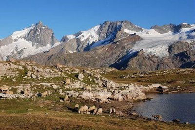
Troupeau d'ovins sur le plateau d'Emparis - Denis Fiat - PNE  Panorama
The Emparis Plateau
The mule path follows the edge of the Southern border of the plateau which is completely dedicated to pastoralism and tourism. It offers an exceptional view of the Meije whose marked relief contrasts with this gentle landscape. It welcomes 7 refuges and pastoral cabins as well as remarkable fauna, like the Mountain Hare and the Mountain Apollo butterfly. The challenge for this site is to preserve its pastoral character.
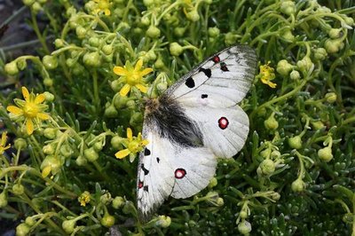
Petit apollon sur sa plante hôte (saxifrage faux aizoon) - Bernard Nicollet - PNE  Fauna
FaunaSmall Apollo
The Small Apollo is a rare and protected butterfly. It has finely striped black and white antennae, and a tiny red ocellus (eye) on each of its forewings. With a wingspan of 60 to 80 mm, it is the lord and master of the orangey-yellow beds of mountain saxifrages where it takes care of its eggs and feeds its caterpillars.
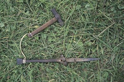
L'enclume et le marteau pour battre la faux - Cyril Coursier - PNE  Know-how
Agricultural work in Spring and Summer
In Spring the soil had to be moved up the land using crates pulled by mules. Ploughing, sowing, planting followed rye (which stayed in the ground for two years), barley, oats and potatoes. Summer was not finished until the barns were full of hay. Scythes that had been beaten on an anvil, rakes, and nets were used every day. In order to ensure the overwintering of the animals, a certain number of loads (around 80 kg of hay) were necessary: 25 for each dairy cow and 5 for each sheep.
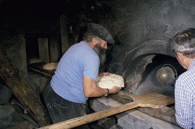
La cuisson du pain noir - Jean-Pierre Nicollet - PNE Know-howAgricultural work in Autumn and Winter
From September, cereal crops were cut with the scythe and the sickle, dried in “bourles” (small stacks of ten sheafs) on the top of the land (fields). Once beaten, the grains of rye were dried in the sun «soleillaient », they were taken to the mill and then to the oven to be made in to black bread. From the end of November until the beginning of May, the animals had to be tended to in the stables. The manure from the cows was transported to the fields using sledges, while the sheep dung was dried and cut in to, pieces, and burnt to produce heat and energy for cooking. In the dairy, milk was made in to butter and cheese.
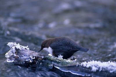
Cincle plongeur - Robert Chevalier - PNE FaunaWhite-throated dipper
Perched on a large, partly immersed pebble, the dipper sways to and fro with its tail aloft, and then dives down head first into the swirling water. This surprising passerine is unusual in moving underwater against the current in search of food. Thanks to a thin membrane protecting its eyes from the water, it can spot its prey (worms, small shellfish, water insect larva), before lifting its head out of the water and letting the current carry it gently along. It then takes up a new surveillance position and starts the process all over again.
 Panorama
Chazelet perch
To test your head for heights, there is nothing like this new, life-size game played facing the Meije a steel walkway suspended over empty space. The first few steps are daunting, but reaching the end of the walkway – or rather, empty space – calls for even more courage! Beneath your feet, all the way down below is the village of Les Fréaux, nestling against the Romanche, and above you, the giants of ice. If you add in the element of air, with gusts of wind blowing all around you, then strong sensations are guaranteed!
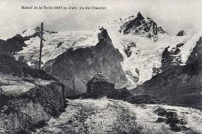
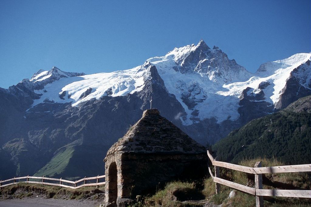
Massif de la Meije vu du Chazelet - PNE  Architecture
Sainte-Anne du Chazelet oratory
Although it stands beside an ordinary road, the Chazelet oratory is famous for one of the most beautiful panoramas of the Alps and the Meije mountains. Built in dry stone, the edifice is at 1 834 m and overlooks the valley and the Ecrins and Meije mountains. It has been sketched, photographed and painted many times, including in the famous Meije by the Japanese painter Foujita.
Recently a new orientation table was placed a few metres above the oratory. In two parts, it shows the northern slope of the Meije and the southern slope in the direction of Chazelet and Savoie.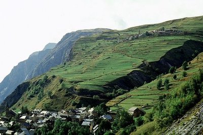
Terrasses, au hameau des Terrasses - Jean-Pierre Nicollet - PNE  Vernacular heritage
La Grave terraces
On the south-facing slope of La Grave, terraced farmland and villages are inseparable. This is a European-wide landscape uniting many architectural, archaeological and natural elements. This mountain farming system was shaped mainly by past and present agricultural activity. The steep terrain at the time required terracing for it to be farmed. These former planted terraces are today natural meadowland, which is mowed or used for grazing. It is highly sensitive to this new pastoral usage, and is little by little showing signs of soil erosion.
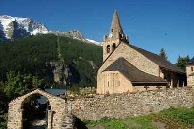
Eglise ND de l'Assomption à la Grave - Jenny Selberg - OT Hautes Vallées ArchitectureNotre-Dame de l’Assomption Church
Listed as an historic monument, Notre Dame de l'Assomption church towers over La Grave. In First Romanesque style, this remarkable building is thought to date from the 11th century, making it the oldest building in the town. All around the church is a cemetery with graves marked by wooden crosses and decorated with brass hearts, facing the giants of ice.
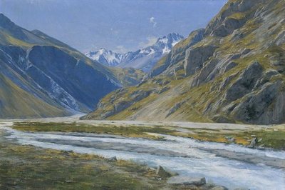
Vallée de la Romanche, Charles Bertier - © Musée de Grenoble  History
Romanche valley, Charles Bertier
The Romanche was a source of inspiration for many mountain artists and it have been painted repeatedly. Charles Bertier (1860-1924) was inspired to paint Vallée de la Romanche au Pied-du-Col and Les Fréaux près de la Grave, two oil paintings that were painted in 1894. The artist from Grenoble learnt to paint landscapes with Jean Achard, and mountains with the abbot Guétal and did not hesitate to set up his easel on the high summits of the Dauphiné Alps. More to the point, his mission was to make his contemporaries 'understand the mountains'!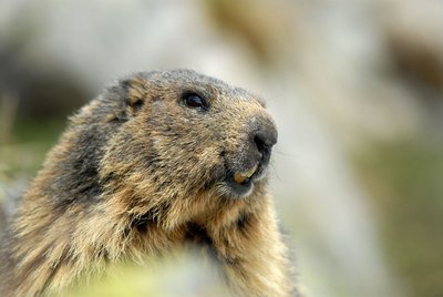
Marmotte au printemps - PNE - Papet Rodolphe FaunaThe marmots’ "bosse"
The alpine marmot is naturally present on grass at altitude. Here, it occupies a singular place which we call the marmots’ "bosse». This hibernating rodent is only visible between April and October. The marmot lives in a family and respects a hierarchy. Games, grooming, fighting and biting ensure the dominance of a couple as well as the cohesion of the group. Each animal participates in the delimitation of the territory by rubbing its cheeks on rocks and also by urinating and defecating there. When there is danger, the marmot emits a high and powerful whistle in order to warn the others.
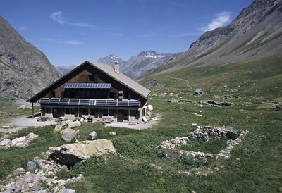
Le refuge de l'Alpe - PNE - Coursier Cyril  Hut
HutThe Alpe Refuge
The Alpe refuge is situated at the intersection of two heavily frequented valleys making it a key stage for discovering this sector of the Massif des Ecrins. The GR 54 links it, by the Arsine mountain pass, to the valley of the Guisane. From here it is possible to reach the Pavé and the Adèle Planchard refuges... Above the refuge, the high mountains begin. The ice cap of the Agneaux, by the North West slope, and the crossing by the Neige Cordier peak to go back down to the Blanc glacier are two classic snow climbs.
details.BAMwidget
Source

Report a problem or an error
If you have found an error on this page or if you have noticed any problems during your hike, please report them to us here: