13. From Lake Muzelle to Le Bourg-d’Oisans via the Col du Vallon (stage of the GR 54)
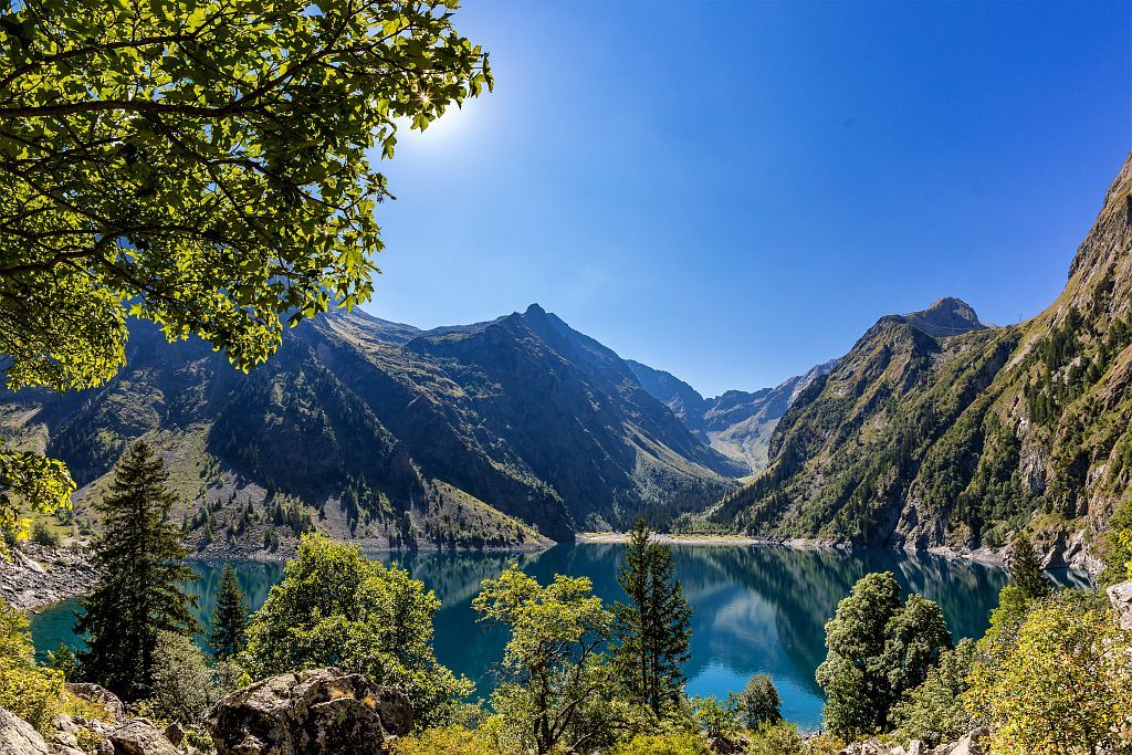
The Col du Vallon is the passage between the two mountain lakes that have made the two valleys overlooking the Vénéon famous. The Lauvitel valley is a totally preserved natural area with a paved footpath, while the Muzelle valley is enhanced by pastoral farming, refuges and peat. The classic GR 54 footpath follows the Lauvitel valley and arrives just before the village of La Danchère. The end of this great adventure takes us along the left bank of the Vénéon, then the lake basin, and concludes gently in Le Bourg d'Oisans, which we left two weeks earlier!
Description
Walk along the right-hand side of the lake as far as the spillway and then cross the bridge.
- At the fork, head right towards the pastures. Walk through the rocky area, following the cairns. The path continues through the Combe des Ruines valley as far as the mountain pass (2 531 m) along a steep grassy slope. Follow the right bank of the Embernard stream down to the Lauvitel through a meandering route across rocky slabs and a valley. You arrive at Lake Lauvitel with its chalets through the Selles meadow.
- From there, walk to the River Danchère after taking the right-hand fork. You descend an old paved path lined with low walls.
- At the second footbridge (1 010 m), take the footpath to the left as far as Les Gauchoirs (850 m). The right-hand footpath leads to the peaceful village of La Danchère (inn and restaurants). Cross Les Gauchoirs and walk as far as the Vénéon mountain stream, and follow the left bank. The footpath goes under the Pisse waterfall and joins up with the road. Follow the left-hand road into the forest.
- Walk along the Fournol canal and, at the entrance to the village of Le Vert, take the left-hand road, the Chemin de Ville Noire, to arrive in Le Bourg d'Oisans past the Minerals and Fauna Museum.
- Departure : Lake Muzelle, Venosc
- Arrival : Le Bourg d’Oisans
- Towns crossed : Les Deux Alpes and Le Bourg-d'Oisans
Altimetric profile
Recommandations
The passage between the mountain pass and Lake Lauvitel on a rocky outcrop (at about 1 850 m) can prove dangerous when it is raining.
It is possible to take a short cut by stopping in La Danchère at the Lauvitel gîte (5 hrs 30 min).

Sensitive areas
- Impacted practices:
- Aerial, Aquatic, Land, Vertical
- Sensitivity periods:
- JanFebMarAprMayJunJulAugSepOctNovDec
- Contact:
- Parc national des Écrins.
Golden eagle
- Impacted practices:
- Aerial, , Vertical
- Sensitivity periods:
- JanFebMarAprMayJunJulAug
- Contact:
- Parc National des Écrins
Julien Charron
julien.charron@ecrins-parcnational.fr
Peregrine falcon
- Impacted practices:
- Aerial, Vertical
- Sensitivity periods:
- FebMarAprMayJun
- Contact:
- Parc National des Écrins
Julien Charron
julien.charron@ecrins-parcnational.fr
8 points of interest
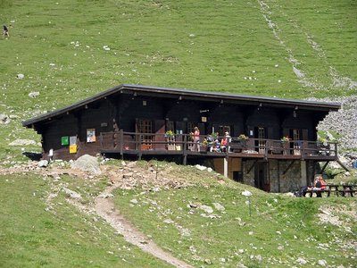
Le refuge de la Muzelle - PNE - Albert Christophe  Hut
HutMuzelle refuge
The bottom of the valley comes up to the rock wall at Muzelle, the pic du Clapier du Peyron and the head of the Muraillette. The modern history of this place is marked by mountaineering. It was on the 2nd July 1875 that Coolidge guided by Almer father and son opened the normal way to Roche de la Muzelle by the East North East face and the North-East ridge.. At this time, even if a pastoral cabin was used by the mountaineers the bivouac was still often used in the Muzelle valley. In 1967, it was in the rocky cirque that the community built the refuge on the shore of Muzelle lake.
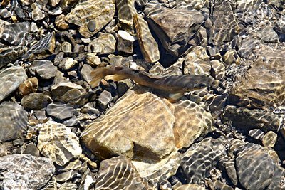
La truite fario - PNE - Telmon Jean-Philippe  Lake
LakeLac de la Muzelle
The Lac de la Muzelle is a glacier lake with cold waters, poor in life. The fish population is limited to salmonids (Arctic char, brook trout, etc.). Their active period is limited to summer. Since their food sources are low, they suffer from dwarfism. Each year, scientific monitoring is carried out by various universities and the National Park: samples of fish, phytoplankton, zooplankton and physical measurements.
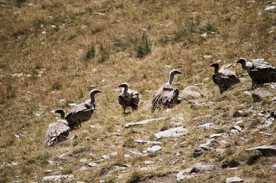
Vautours fauves - Marion Molina  Fauna
FaunaGriffon vultures
From the Col du Vallon, you can sometimes see griffon vultures. The bird returned to the mountains a few years ago. Bigger than an eagle, with beige and brown plumage, it generally glides in flight, and its movements are broad and slow. But what characterises the species above all is its gregariousness: griffon vultures like to be together, whether on the ground or in the air. This behavioural adaptation makes it easier for them to find the animal carcasses they feed on.
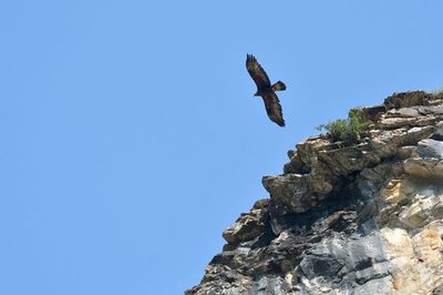
Aigle royal en vol - Mireille Coulon - PNE FaunaGolden eagles
Several birds of prey cross the skies above L’Oisans. Among them are two couples of golden eagles that share the Muzelle and Lauvitel valleys. They have an impressive wingspan (2.30 m on average), are mostly brown colour, and often hunt marmots at low altitude.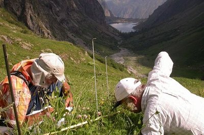
Réserve intégrale du Lauvitel, relevé des lignes de lecture de la végétation - Denis Fiat - PNE  Flora
FloraRéserve intégrale du Lauvitel
The Lauvitel full reserve area was created on 9 May 1995, and is a first in France in a National Park. It lies at the end of the valley and has been owned by the state since 1980. This area, where all human activity is forbidden, is a site for scientific observation of an environment over the long term. Vegetation, animals, water and climate are studied and compared with the data from other sites. Access to the reserve is strictly forbidden except for scientific purposes.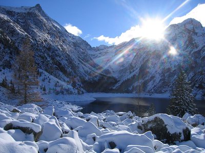
Lac du Lauvitel enneigé - PNE LakeLauvitel Lake
Lauvitel Lake is the biggest (around 25-35 ha) and the deepest (40-65 m) in the Ecrins National Park. A rocky landslide around 4000 years ago, added to an existing glacial moraine to form a natural dam capable of retaining such a volume of water. The waters of the lake are cold and well oxygenated. They suit several species of fish including the Arctic Char or the Brown Trout which were introduced for anglers. Today the Lake Lauvitel is the subject of numerous scientific studies: physical parameters, sediment, phyto et zooplankton are collected and analyzed.
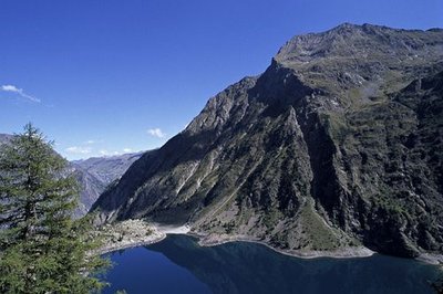
La digue du lac du Lauvitel - Denis Fiat - PNE  Geology and geography
Natural Dam
Around 4000 years ago, a rocky landslide added to an existing glacial moraine to form a natural dam capable of retaining this large volume of water. The seasonal variation of the level of the lake of 20 to 25 m is due to the permeability of the materials making the dam. In fact the lake does not have a spillway and the water infiltrates the boulders of the dam. It offers a beautiful view of the lake which infact inspired the painters at l'Abbé Guétal.
Au châlet de pêche - Denis Fiat - PNE  History
Chalets at altitude
On the Lauvitel dam are ancient prairie chalets as well as chalets that were built between the two World Wars to welcome hunters and anglers. Formally a private property, this valley was rented out to the ‘Bourgeoisie Dauphinoise’ for hunting. Angling, on the other hand, is still practised: it is managed by the Lauvitel Society for private angling. One of the chalets is still used to today to house agents from the Ecrins National Park and scientists from the nature reserve.
details.BAMwidget
Source

Report a problem or an error
If you have found an error on this page or if you have noticed any problems during your hike, please report them to us here: