5. From Monêtier-les-Bains to Vallouise via Col de l’Eychauda (stage of the GR 54)
A brief foray into the Guisane valley, better known as the Serre Chevalier valley, and already the summits are rising all around us. The climb is gentle and shaded, and arrives in the alpine pastures with their Monêtier ski-lifts. We must wait until Col de l'Eychauda to leave the landscaped areas and take in the breathtaking view over the Chambran valley. A stop at the pastoral hut is also an invitation for a stroll. But there is still a long way to go and Vallouise, lower down, is full of treasures.
Description
Opposite the Grands Bains, go past the Arts et Vie (SO) residence along a road leading to a car park.
- Turn left towards Peyra Juana. 200 metres further on, take the right-hand footpath towards the Saint-Antoine du Charvet chapel (1 608 m). Walk around the chapel and then go up along the footpath on the right.
- At the next intersection, stay on the GR footpath to the left. The path follows La Selle mountain stream beneath the crests of the Lauzières. It then leaves the forest near the high-altitude restaurant and the departure point for three chairlifts.
- Continue along the valley on the left under the Eychauda chairlift as far as the mountain pass of the same name (2 425 m). On the left you pass by the Col de la Cucumelle footpath. The route down the Neyzet ravine goes under one more chairlift. On the left you pass by the paths to Col de Fréjus and Col de La Pisse. Under the Roche Gauthier, the route descends a rocky escarpment, then the footpath runs along the Sastrière ravine and across a series of three ravines.
- At the ruins of the Riou-la-Selle chalet (1 750 m), the wide footpath joins up again with the track going up to the "Lac de l'Eychauda". Walk along the road as far as the Chambran chalets (1 715 m). Continue along the road that runs alongside the torrent.
- Take the path to the right (1689 m), which crosses the road to meet it again at a lower level. Follow the road for 300 metres, then rejoin the path after the house on the bend (1531 m). At the Baumasse ravine (1417 m), cross the road and join a path beneath the road. This path follows the road and then bends left to continue downhill towards Vallouise.
- At the junction, turn right towards Le Riou. The path crosses the road and rejoins it a little further down. Follow the road for a few metres to find the path on the left at the bend. This path ends in a street that you have to walk down to get back onto the main road.
- Cross the road and go over the bridge over the torrent. Just after the bridge, turn left onto the path that follows the torrent. Go past the sports fields and swimming pool and continue along the torrent until you reach a bridge, which you must cross to continue along the left bank towards Vallouise. Cross the bridge to reach the village centre.
- Departure : Le Monêtier-les-Bains
- Arrival : La Vallouise
- Towns crossed : Le Monêtier-les-Bains and Vallouise-Pelvoux
Altimetric profile
Recommandations

Sensitive areas
Black grouse - winter
- Impacted practices:
- , Land
- Sensitivity periods:
- JanFebMarAprDec
- Contact:
- PN Ecrins BERGEON Jean-Pierre jean-pierre.bergeon@ecrins-parcnational.fr QUELLIER Hélène helene.quellier@ecrins-parcnational.fr Membre de l OGM ogm.vds@gmail.com ogm.amblard@gmail.com
19 points of interest
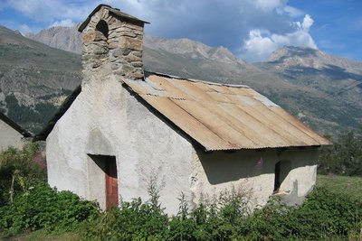
Chapelle Saint-Antoine du Charvet - © Florence Chalandon  History
Charvet Chapel
Near the arrival of the old Charvet button lift, dating from 1948 (still present, but disused since the end of the 2003/2004 season), is the Charvet chapel, which was built in 1755. Easy to access both in summer and winter from Le Monêtier, it provides hikers with a wonderful panorama over the southern Guisane valley.
It is quite unusual for a chapel in the region to be dedicated to Saint Anthony of Padua rather than to Saint Anthony the Great. Was there a shift in patronage over time? The fact the saints had the same name led to the particular qualities of each one being mixed up.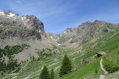
Vallon de l'Eychauda - Office de tourisme Pays des Écrins  Pastoralism
The old hay meadows
Lower down as you cross the area, near the pastoral Cabane de l'Eychauda, you can make out piles of stones, the clapiers formed by the removal of stones from the hay meadows. In order to feed the livestock right through the winter, it was necessary to garner a large amount of hay! With changes in livestock farming practices, there are no longer cut for hay, but used for grazing. Only a tiny area of the valley - the flattest - is still mown for hay, mechanically.
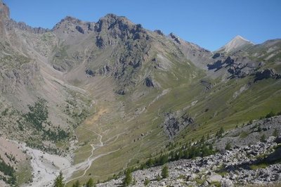
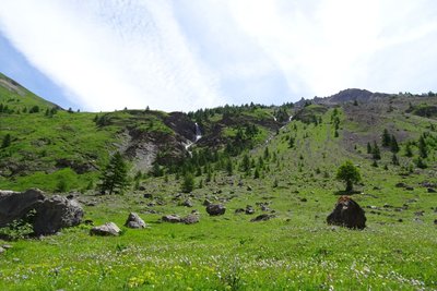
Les deux versants du vallon de Chambran - Marie-Geneviève Nicolas  Geology and geography
The front of the nappes
The two slopes of the Chambran valley are very different: the right bank, minerals are very present. There are granites and gneiss making up the crystalline base of the Ecrins massif. On the left bank, the prairies are sandstone and chalky. These are part of the glacial thrust sheet: they are ancient sediments deposited mostly to the East, in the Alpine ocean, then carried here by compression at the time of the formation of the Alps.
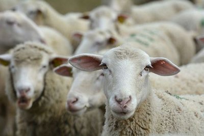
Troupeau de brebis - Mireille Coulon - PNE PastoralismEvolution of pastoralism
In the valley, the ruins of numerous piles of stones resulting from the removal of stones in the hay meadows are witness to another age. Most of these old prairies are now grazed by sheep. Pastoralism has evolved: no more local flocks so less hay, the valley is now occupied by a large flock from the Haute-Provence Alps.
Parc à moutons - Office de tourisme Pays des Écrins PastoralismThe realm of sheep
Together with its entire catchment area, the Chambran valley constitutes an enormous alpine pasture. Sheep belonging to several different owners are gathered here for the summer grazing season. Many of them come from the department of Alpes-de-Haute-Provence. The landscape (sheep paths, old hay meadows), vegetation, built structures (old dairy, pastoral cabins)... everything has been marked by centuries of animal husbandry.
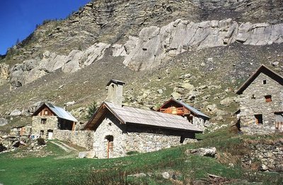
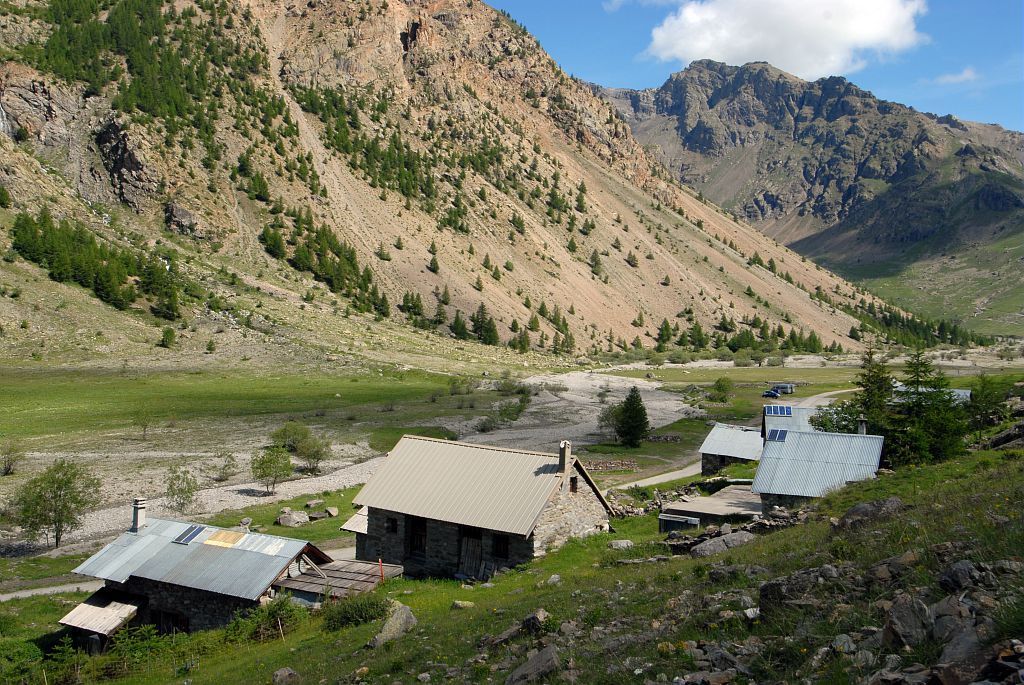
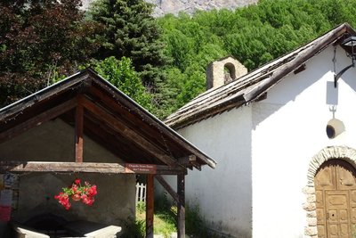
Le hameau de Chambran - Marie-Geneviève Nicolas - PNE HistoryChambran Hamlet
At an altitude of 1700 meters, this hamlet is inhabited in summer, at the beginning of the summer pasture. The old dairy has been spruced up to become a snack bar. It’s pretty little chapel dedicated to Saint Jean is very simple and bare.
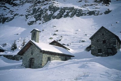
Les chalets de Chambran sous la neige - Marie-Genevève Nicolas - PNE  Vernacular heritage
Chambran chalets
Remnants of a way of life that has disappeared, the Chambran chalets were once a high-altitude village where flocks stayed during the summer months. Today this is a welcome stop along the GR54 and the starting point for hikes towards Lake Eychauda.
Le Canal du Béal Neuf - Office de tourisme Pays des Écrins  Water
WaterASA of Béal Neuf
The ASA (authorised water user association) of Béal Neuf is the owner of the canal. The association manages, maintains and develops the Béal Neuf canal which carries water to the entire network of irrigation canals.
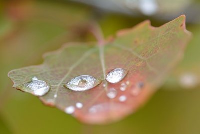
Gouttes d'eau sur une feuille de tremble - Mireille Coulon - Parc national des Écrins  Flora
FloraThe aspen
The path runs through a small aspen wood. This tree with a smooth, greenish trunk and rounded, crenelated leaves takes on magnificent autumn colours. The stem, or petiole, of aspen leaves is flat and twisted, so it can be caught by the slightest breeze making the foliage «quake» hence its common name, the quaking aspen. It grows in places where the soil is quite damp.
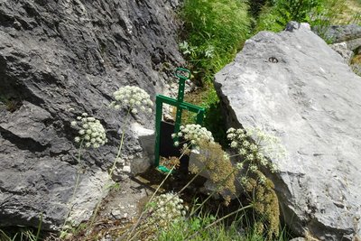
Martelière qui assure la distribution de l'eau - Office de tourisme Pays des Écrins WaterWater in the mountains
Since the Middle Ages, canals have been dug to carry water to the crops. The water is diverted by the canals: through the action of gravity, the water flows down the mountain sides. Use of the water is regulated and for any draw-off, the volume is measured.
La chapelle aau Fangeas - Office de tourisme Pays des Écrins Vernacular heritageThe minor heritage of Pelvoux
Every hamlet has its own chapel. In the territory of Pelvoux, Les Claux has the chapel of Sainte-Barbe with a restored sun dial dating from 1792. The seventeenth-century chapel of Saint-Pancrace is in Le Poët. In Le Sarret, you can admire the chapel of Saint-Joseph and the chapel of Notre-Dame des Sept Douleurs stands in Le Fangeas. Every hamlet has its own communal oven and water fountains as well. Finally, the church of Saint-Antoine is located in the hamlet of Saint-Antoine. It has a sun dial dating from 1810.
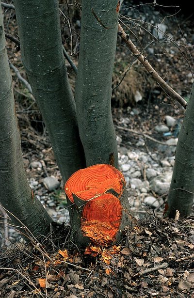
L'aulne blanc - Nicollet Bernard - Parc national des Ecrins FloraThe grey alder
In the valleys of the Alps and the Jura, the grey alder often grows in place of the black alder, present in many parts of France. Like its cousin, it grows on riversides and plays an important role in stabilising the banks. If it is cut down, its wood is bright orange in colour. But why cut it down?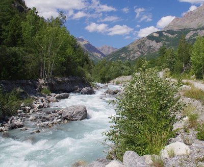
Le Gyr - Office de tourisme du Pays des Écrins WaterThe Gyr
Humans are decidedly bizarre animals: they build, knock down and start again. To protect the new infrastructures of Pelvoux, the Gyr was dammed. But, not able to flow as it did before, it deepened its bed, thus placing the foundations in danger of damage. And so works were carried out to widen its bed, allowing it to flow more naturally. This is also more favourable for biodiversity, as well as protecting the developed urban areas.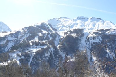
Vue sur la station de Pelvoux-Vallouise - Pelvoux Office de tourisme du Pays des Écrins Vernacular heritageThe ski resort of Pelvoux-Vallouise
The route first leads through the small ski resort of Pelvoux-Vallouise, built in 1982. Very family-focused, in winter it's the ideal place for young children to learn to ski, with small lifts lower down, while their big brothers and sisters can ski higher up.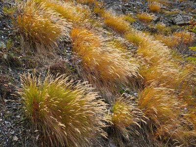
Le calamagrostide argentée - Nicolas Marie-Geneviève - Parc national des Écrins FloraSilver spike grass
A grass grows in large clumps on the embankment: silver spike grass. It is adapted to stony, dry and sunny ground. Its inflorescences reflecting silvery-gold glints create a beautiful effect, but they are particularly noticeable in the late summer, when it forms large shimmering bouquets in the evening sunlight.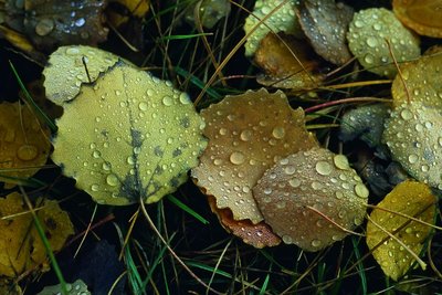
Des feuilles de tremble - Bernard Nicollet - Parc national des Écrins FloraThe aspen
On the right, a stand of aspens with smooth, greenish trunks and rounded, crenelated leaves take on magnificent colours in autumn. The stem, or petiole, of aspen leaves is flat and twisted, so it can be caught by the slightest breeze making the foliage «quake» hence its common name, the quaking aspen.
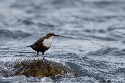
Cincle plongeur - Mireille Coulon - Parc national des Ecrins  Fauna
FaunaThe white-throated dipper
Perched on a rock in the middle of the river, a squat bird with a short tail, brown with a large white bib, bobs up and down with his tail in the air. He then dives and only reappears a few moments later. This is how this bird hunts, diving into the water and then walking against the current along the river bed searching for aquatic insect larvae, small crustaceans or small fish, lifting pebbles with its beak to dislodge them.
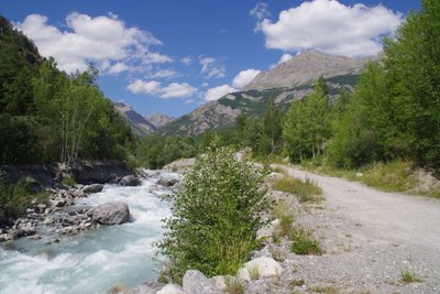
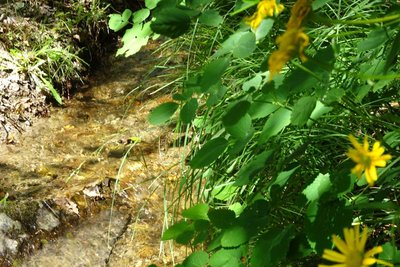
Forêt au bord du Gyr - Office de tourisme Pays des Écrins FloraForest on the water's edge
This small wood is a fragment of the riparian forest: natural forest growing adjacent to a body of water. Reduced everywhere due to urbanisation, this type of forest is made up of alder, willow and oak, and also poplar, birch and aspen, among others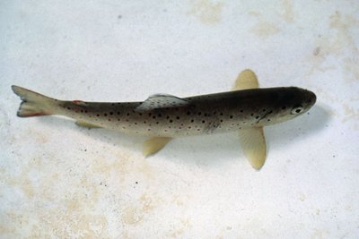
La truite fario - Parc national des Écrins FaunaThe trout
But what's the angler angling for? The brown trout of course! This is the mountain fish par excellence, with a streamlined body to withstand the current more efficiently and light brown skin speckled with black and red. It lives in cold, oxygen-rich waters.
details.BAMwidget
Source

Report a problem or an error
If you have found an error on this page or if you have noticed any problems during your hike, please report them to us here: