
1. From Saint-Martin-de-Queyrières to Vallouise (stage on the Super Noir - trail no. 15)
Follow rippling mountain streams, get up close to the Montbrison massif, cross the Vallouise pass, discover Ailefroide: a subtle mix for this Stage of the Pays des Ecrins between Saint-Martin-de-Queyrières and Vallouise.
Description
From the campsite, head towards the village of Prelles along the road that follows the railway track.
- Cross the railway track and the N94 to reach Prelles (Caution! This is a dangerous and busy road) and then go through the village. Head towards Sachas via the D336.
- At the bend in the road, look out for the path on the right; join it and follow the Sachas mountain stream.
- Cross the Sachas and bear left heading towards Ratière. The path crosses the Pra Piouzéou and Les Banchets. Skirt around Ratière.
- Take the path on the right.
- Take the path on the left and then, after approximately 1 km, start to descend by bearing left to reach the Vallouise pass and the Chouvet cabin beyond. After the Cabin, carry straight on until you reach Choulières.
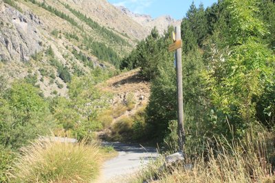
- At the D421T intersection, turn left and take the path on the right after the next bend in the road. Carry straight on as far as Ailefroide. Continue straight on through Ailefroide and take the D994E heading towards Vallouise. At Serre, continue straight on.
- At Les Claux, turn right. At the D994T intersection, take a right turn and join the path on the left before the tunnel. Then carry on along the D994T.
- Keep a lookout for the path on the left; join it and carry on towards Vallouise following the Gyr.
- Departure : L’Iscle de Prelles campsite, Saint-Martin-de-Queyrières
- Arrival : Church of Vallouise, Vallouise
- Towns crossed : Saint-Martin-de-Queyrières, Puy-Saint-André, and Vallouise-Pelvoux
Altimetric profile
details.BAMwidget
Recommandations
The N94 is a dangerous and busy road, take care when crossing it.
Before setting off, it is very important to check the opening periods for this route on the website: https://stationdetrail.com/fr/stations/le-pays-des-ecrins/parcours
Check weather conditions before setting off
Rescue services contact details: Secours Montagne (Mountain Rescue): +33 (0)4 92 22 22 22 or 112
Show consideration for the work of farmers, livestock keepers and owners
Close all gates behind you
Take your litter home
Do not take shortcuts across pastureland
The trail routes are also suitable for walking
 In mountain pastures, protection dogs are there to protect the herds from predators (wolves, etc.).
When I hike I adapt my behavior by going around the herd and pausing for the dog to identify me.
Find out more about the actions to adopt with the article "Protection dogs: a context and actions to adopt".
Tell us about your meeting by answering this survey.
Information desks
23 Avenue de la République, 05120 L'Argentière-La Bessée

Vallouise Park house
, 05290 Vallouise
Information, documentation, models, exhibitions, screenings, product sales and works of the Park. Guided tours for school, reservation required. The new Park House opened in Vallouise since June 1, and offers visitors an interactive permanent exhibition inviting to explore the area and its heritage. A temporary exhibition space will allow a renewed offer. Finally, the device is completed by an audiovisual room to organize screenings and conferences Free admission. All animations of the Park are free unless otherwise stated.
Transport
Public transport >> www.pacamobilite.fr
Consider car-sharing >> www.blablacar.fr
For more information, ask at the Tourist Information Office nearest to the trail starting point.
Access and parking
10 km from L'Argentière-La Bessée, take the N94.
Parking :
Sensitive areas
- Impacted practices:
- Land, Vertical
- Sensitivity periods:
- JanFebMarAprMayJunJulAugSepOctNovDec
- Contact:
LPO PACA antenne de Briançon
0492219417
hautes-alpes@lpo.fr
Golden eagle
- Impacted practices:
- Aerial, , Vertical
- Sensitivity periods:
- JanFebMarAprMayJunJulAug
- Contact:
- Parc National des Écrins
Julien Charron
julien.charron@ecrins-parcnational.fr
Golden eagle
- Impacted practices:
- Aerial, , Vertical
- Sensitivity periods:
- JanFebMarAprMayJunJulAug
- Contact:
- Parc National des Écrins
Julien Charron
julien.charron@ecrins-parcnational.fr
Black grouse - winter
- Impacted practices:
- , Land
- Sensitivity periods:
- JanFebMarAprDec
- Contact:
Black grouse - winter
- Impacted practices:
- , Land
- Sensitivity periods:
- JanFebMarAprDec
- Contact:
- Parc national des Ecrins - 0492402010
Black grouse - winter
- Impacted practices:
- , Land
- Sensitivity periods:
- JanFebMarAprDec
- Contact:
- LPO Paca antenne des Hautes-Alpes
0492219417
hautes-alpes@lpo.fr
http://paca.lpo.fr/partias
18 points of interest
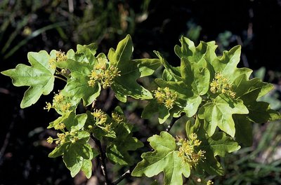
Érable champêtre - Nicollet Bernard - Parc national des Écrins  Flora
FloraThe field maple
This is the smallest member of the family of forest maples, growing to a height of 8 to 15 metres. It can live for up to 150 years. Its leaves have five round lobes; they are winged with wings sticking out in opposite directions. It is not fussy as to the dampness of the soil and it can withstand cold temperatures and drought. It is also an excellent bee forage plant, which can be enhanced by the proximity of a hive.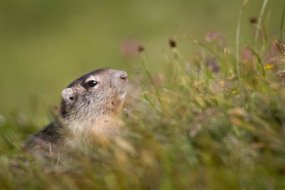
Une marmotte - Thibault Blais Photographie  Fauna
FaunaThe marmot
In the alpine pastures, the iconic marmot utters a loud high-pitched whistle to warn its neighbours of approaching danger: the golden eagle is on the prowl! This medium-sized rodent prefers to live in the high-mountain grasslands in family groups. Their favourite pastimes are gnawing, digging, taking a siesta in the sunshine and performing somersaults. In the winter, the marmot takes refuge in its burrow where it hibernates. It is only seen between the months of April and October. It marks the boundary of its territory by rubbing its cheeks on the rocks or leaving droppings.
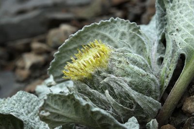
Bérardie laineuse - Cédric Dentan - Parc national des Écrins FloraThe woolly berardia
The woolly berardia is a plant that grows approximately 10 centimetres tall and has a short, almost non-existent stem. This perennial member of the Asteracea family grows in limestone and schist screes. It has veined oval, woolly leaves which are covered in soft hairs. Its 4 to 7 cm compact head with pale yellow flowers stands up from its centre.
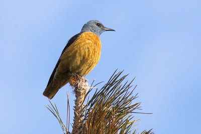
Le monticole de roche - Pascal Saulay - Parc national des Écrins FloraThe common rock thrush
In May, a melodious song rings out from the cliff top. It’s the song of the common rock thrush, appropriately named and a wonderful bird. Although the female is rather dull (an advantage when egg-sitting) the male sports an orange underside and a blue-grey head. A trans-Saharan migratory bird, every year it returns to the mountains of Southern Europe where it frequents the rocky, sunlit slopes. It is not very common and is in decline, so spotting it is even more special!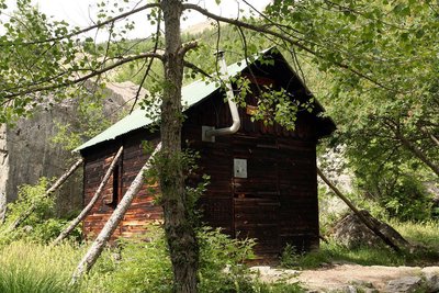
La Cabane de Chouvet - Marie-Geneviève Nicolas - Parc national des Écrins  Vernacular heritage
The Cabane de Chouvet
Discover one of the most famous forest cabins in the Vallouise valley, the Cabane de Chouvet. Surrounded by larches, Scots pines and black pines, this unmanned cabin stands at an altitude of 1,860 metres. On this slope, the mountain land has been under restoration since 1914 to prevent erosion and to combat deforestation.
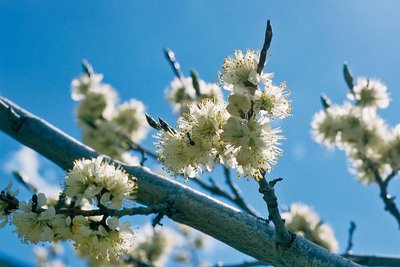
Prunier de Briançon - Bernard Nicollet - Parc national des Écrins FloraThe Briançon plum tree
Not far from the Cabane de Chouvet, some small trees grow which are covered in white flowers in the springtime. This is the Briançon plum tree. Later in the year, it will produce golden plums with a tart flavour, carried on a very short stalk. A species endemic to the southwestern Alps, it has been prized by man because the kernel inside its stone produced a very fine oil, called huile de marmotte (marmot oil).
Les Choulières - Office de tourisme du Pays des Écrins  History
Les Choulières
The French children's song Savez-vous planter les choux? (Do you know how to plant cabbage?) is very appropriate here! In any event, the name Choulières is believed to be a reference to a place planted with cabbages and, by extension, a place where vegetables are grown. The phasing out of crop cultivation in the mountains has altered the landscape: the hay meadows and fields are now used as grazing meadows for increasingly large flocks of sheep.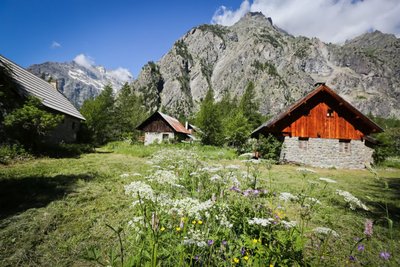
Ailefroide - Jan Novak Photography  Top
TopAilefroide
Formerly an alpine pasture hamlet, Ailefroide lies at the foot of Mont Pelvoux, surrounded by larch woods and granite cliffs. It is the last hamlet in the valley, at the confluence of the valleys of Saint-Pierre and Celse Nière. The name Ailefroide is thought to originate from the term Alpe froide or “cold Alp”, a reference to the lack of sun here in the winter. It is the starting point of numerous trails and is a paradise for climbers. Ailefroide is a legendary destination for mountaineers: a stele commemorates the conquest of Mont Pelvoux in 1828.
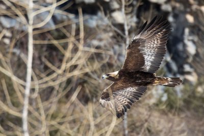
L'aigle royal - Pascal Saulay - Parc national des Écrins FaunaThe golden eagle
A pair of eagles lives in the Ailefroide valley. Every pair has a very large hunting territory, which means there can be no more than one pair in a small valley of this size. This pair has built several eyries in the cliff walls around Ailefroide: just one is occupied every year, after a few refurbishments. The eyries are located at the lower altitudes of the hunting territory, so that the eagles can easily bring heavy prey back to the eaglet.
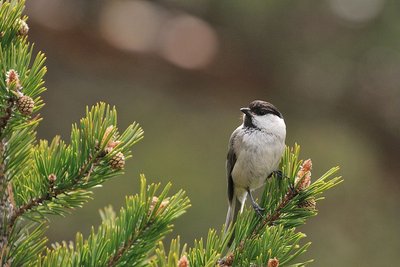
La mésange boréale - Mireille Coulon - Parc national des Écrins FaunaThe willow tit
A soft call, a series of short repetitive notes, is heard in the forest. It's the call of the willow tit, also known as the alpine tit. As for its plumage, it has a greyish brown back, beige underparts, a white head with a black cap and a little black bib, It lives in mountain forests. It is the double of the marsh tit, which tends to live below 1,400 metres.
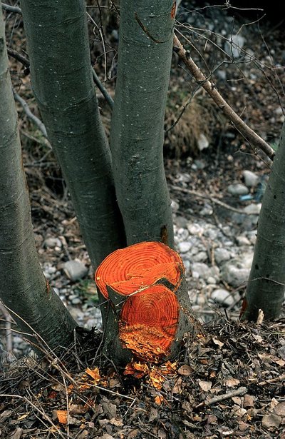
L'aulne blanc - Nicollet Bernard - Parc national des Ecrins FloraThe grey alder
In the valleys of the Alps and the Jura, the grey alder often grows in place of the black alder, present in many parts of France. Like its cousin, it grows on riversides and plays an important role in stabilising the banks. If it is cut down, its wood is bright orange in colour. But why cut it down?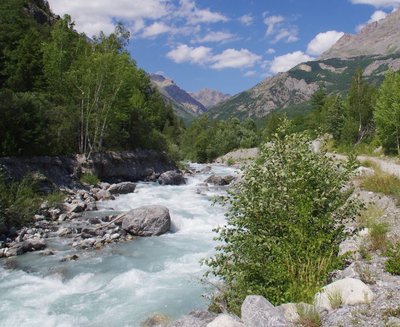
Le Gyr - Office de tourisme du Pays des Écrins  Water
WaterThe Gyr
Humans are decidedly bizarre animals: they build, knock down and start again. To protect the new infrastructures of Pelvoux, the Gyr was dammed. But, not able to flow as it did before, it deepened its bed, thus placing the foundations in danger of damage. And so works were carried out to widen its bed, allowing it to flow more naturally. This is also more favourable for biodiversity, as well as protecting the developed urban areas.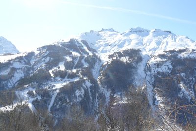
Vue sur la station de Pelvoux-Vallouise - Pelvoux Office de tourisme du Pays des Écrins Vernacular heritageThe ski resort of Pelvoux-Vallouise
The route first leads through the small ski resort of Pelvoux-Vallouise, built in 1982. Very family-focused, in winter it's the ideal place for young children to learn to ski, with small lifts lower down, while their big brothers and sisters can ski higher up.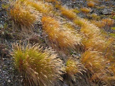
Le calamagrostide argentée - Nicolas Marie-Geneviève - Parc national des Écrins FloraSilver spike grass
A grass grows in large clumps on the embankment: silver spike grass. It is adapted to stony, dry and sunny ground. Its inflorescences reflecting silvery-gold glints create a beautiful effect, but they are particularly noticeable in the late summer, when it forms large shimmering bouquets in the evening sunlight.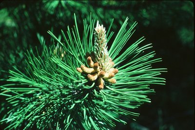
Aiguilles de pin sylvestre - Parc national des Écrins FloraForest of pine and oak
The path now alternates between cleared areas and forested areas. This forest contains Scots pine (recognisable by its orangey coloured trunk, especially at the top), downy oak (its young branches and leaf undersides covered with a fine down), and larch. The Scots pine and downy oak are very drought-tolerant (it is very limey soil here) and can also withstand low temperatures, and they are typical of the montane zone in this part of the Alps.
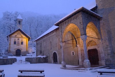
L'église Saint Etienne (à droite) et la chapelle des pénitents (à gauche) - Thierry Maillet - PNE  Architecture
Saint-Étienne de Vallouise Church
Listed and protected as an historic monument since 22 October 1913, the church dedicated to Saint Stephen is one of the most beautiful religious edifices in Hautes-Alpes. It is typical of the Romanesque churches in the Briançon region built in the second half of the 15th century, although its exact construction date is still uncertain.
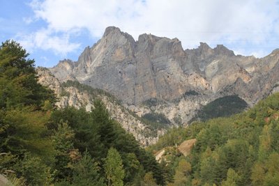
Le massif du Montbrison - Office de tourisme Pays des Écrins  Panorama
The Montbrison massif
The path offers a beautiful overall view of the limestone massif of Montbrison, overlooking the hamlets of Pelvoux with the peaks of the Cime de la Condamine, the Tête des Lauzières, the Pic de Montbrison and the Tête d'Amont.
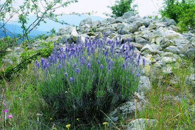
La lavande à feuilles étroites - Jean-Pierre Nicollet - Parc national des Écrins FloraThe narrow-leaved lavender
The path crosses some limestone screes. It is a dry environment. The narrow-leaved lavender grows in sunny areas, a reminder that the Pays de Écrins is in the Southern Alps after all! Not to be confused with the lavandin, this plant naturally grows on rocky slopes in the mountains of the Midi.
More information
Source

Report a problem or an error
If you have found an error on this page or if you have noticed any problems during your hike, please report them to us here: